You are using an out of date browser. It may not display this or other websites correctly.
You should upgrade or use an alternative browser.
You should upgrade or use an alternative browser.
Orbiter Screenshot Thread
- Thread starter Tex
- Start date

I was thinking about something like an ultralight with oversized wings and maybe solar-powered propeller. Could that work?
- Joined
- Apr 14, 2012
- Messages
- 2,584
- Reaction score
- 0
- Points
- 36
I was thinking about something like an ultralight with oversized wings and maybe solar-powered propeller. Could that work?
Hlynacg was thinking about it a while ago:
http://www.orbiter-forum.com/showthread.php?t=32091
Don't think he actually did anything with it just yet though.
And by the way, it looks awesome!!!!!!!!!!!!!!!!!!!!

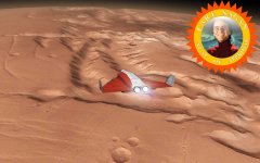
Goodbye to flat Mars: Noctis Labyrinthus and Valles Marineris in 3D.

By the way: are there any addons with dedicated aircraft for the Martian atmosphere? Trying to do a low-altitude flight with a DG is a bit of a nightmare.
Does [ame="http://www.orbithangar.com/searchid.php?ID=2581"]this[/ame] work?
PeterRoss
Our friendly neighborhood Putinist
Goodbye to flat Mars: Noctis Labyrinthus and Valles Marineris in 3D.
Yes, yes yes!!!!!!!:woohoo:
Slaintemaith
Old Timer
- Joined
- Jul 5, 2011
- Messages
- 76
- Reaction score
- 0
- Points
- 6
Goodbye to flat Mars: Noctis Labyrinthus and Valles Marineris in 3D.
By the way: are there any addons with dedicated aircraft for the Martian atmosphere? Trying to do a low-altitude flight with a DG is a bit of a nightmare.
GREAT SCOTT!!!! That looks really awesome.
What Mars texture is used here?
The texture is exactly the same as the L11 textures for the current Orbiter version. They are derived from the 256 pixel-per-degree versions of the Mars Orbiter Camera (MOC) on Mars Global Surveyor.What Mars texture is used here?
What's new are the elevation data. They come from 128 pixel-per-degree Mars Orbiter Laser Altimeter (MOLA) data, also on Surveyor.
Funny enough, although both instruments were sitting on the same probe, their respective processed data turned out to be somewhat lacking in compatibility. The MOC data are mapped into an areographic frame, while the MOLA data use an areocentric frame. It took me a bit of headscratching before I figured that out and came up with the correct nonlinear interpolation. Also, I found a spurious shift in longitude between the two datasets which I fixed by eyeballing. Seems like the research teams operating the different instruments didn't talk much between each other.
")
Incidently, the MOC data are monochrome (at least the sources I found), so there is no colour information in the textures (other than the fake tint I am applying). Are there any high-res multi-band global maps out there that could be used for colouring the textures?
Will there be a working surface tile system, for both textures and heightmaps? My base is built in a quite hilly are, so it would be doomed if I can't flatten the area.
_________________________________________
So I decided to rebuild and match my bases' tiles for the BMNG January textures.
I so hope you don't use the same source for the new Orbiter textures as Orbiter Base Maker...

Looks like I can scrap level 1 and 2 textures...
A big part of the Teutoburg Forest copied & pasted. It actually looks fine but I'm too familiar with the area to be happy with it...
_________________________________________
So I decided to rebuild and match my bases' tiles for the BMNG January textures.
I so hope you don't use the same source for the new Orbiter textures as Orbiter Base Maker...
Looks like I can scrap level 1 and 2 textures...
A big part of the Teutoburg Forest copied & pasted. It actually looks fine but I'm too familiar with the area to be happy with it...
Last edited:
- Joined
- Apr 14, 2012
- Messages
- 2,584
- Reaction score
- 0
- Points
- 36
We'll need export/import tool for heightmaps. I plan to do some planetary scale engineering.
Agreed. Is there any possibility that the new terrain system could be backwards compatible with the Orulex cfgs and greyscale height bitmaps, or will it all need to be written from scratch? At the very least, I hope that it will support using greyscale bitmaps for lower-res heightmaps, or it will cause me rather great headaches :lol:
A big part of the Teutoburg Forest copied & pasted. It actually looks fine but I'm too familiar with the area to be happy with it...
As someone totally unfamiliar with it I couldn't even call that fine. The copying is very noticeable.
As someone totally unfamiliar with it I couldn't even call that fine. The copying is very noticeable.
True. Only the edges of the copied part are fine, they are very smooth.
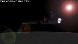
I'm quite happy with the results. Will make the approach to my base much more interesting. (The building with the longest shadow is as large as an Arrow, and used to assemble and launch them vertically).

(click image to enlarge)
- Joined
- Jul 7, 2012
- Messages
- 1,520
- Reaction score
- 1,553
- Points
- 128
- Location
- Monte Hermoso - Argentina
- Website
- github.com
- Preferred Pronouns
- he/him
Good job
What requirements need the future version of Orbiter?
Excellent view of Mars:thumbup:.
Goodbye to flat Mars: Noctis Labyrinthus and Valles Marineris in 3D.
.
What requirements need the future version of Orbiter?
Excellent view of Mars:thumbup:.
Attachments
Hlynacg was thinking about it a while ago:
http://www.orbiter-forum.com/showthread.php?t=32091
Don't think he actually did anything with it just yet though.
Not for Orbiter no.
---------- Post added at 16:13 ---------- Previous post was at 12:21 ----------
Goodbye to flat Mars: Noctis Labyrinthus and Valles Marineris in 3D.
By the way: are there any addons with dedicated aircraft for the Martian atmosphere? Trying to do a low-altitude flight with a DG is a bit of a nightmare.
Professor,
I did a bunch of research on this topic a while back for a science fiction story I've been working on and ended up reusing a lot of that research in a school project down the line. I've actually got meshes and rudimentary code for two martian aircraft sitting in my back-burner/vapor-ware folder.
The first being a mock up of this JPL proposal, and the second being the martian transport that Bruce linked to.
From the looks of things I might want bump their completion up on the priority list.
4throck
Enthusiast !
- Joined
- Jun 19, 2008
- Messages
- 3,489
- Reaction score
- 1,012
- Points
- 153
- Location
- Lisbon
- Website
- orbiterspaceport.blogspot.com
Are there any high-res multi-band global maps out there that could be used for colouring the textures?
NASA's Map-a-planet uses the Viking Color dataset:
"The Viking Color data set is a natural color mosaic, combining the red, green, and blue Viking VIS bands into the respective channels of a color image."
Don't know if it perfectly matches more modern datasets, but since the color variations are very subtle, I think it would work.
________
I second the wish for some compatibility with grayscale height maps.
They already exist and are created from actual real data that's not publicly available on any other format as far a I know(http://stereomoons.blogspot.pt/2010/11/new-moons.html).
For many bodies, that's the best we will have for many decades...
Last edited:


I tested BrianJ's solution for a Moon -> Earth -> Mars flight and on the HTO, I found our world with her little sister next to our closest star. Kinda like a transfer !
Also, completely unrelated, after some work on World Machine:

Normal maps came from the Erosion Flow Map, and the color is the "Coastal Overlay" macro. I made the actual terrain in Blender based on the height map, but I get weird results as I triangulate it for export.
From June 2012: an earlier concept for Hatsunia's first rocket, which was then called Melody-1 instead of Negi-1, and was not similar to the Lambda-4S.

Cheap sketch in MS Paint (with a design for Hatsunia's "old" flag - was thought about after the "current-day" flag was made)

Cheap sketch in MS Paint (with a design for Hatsunia's "old" flag - was thought about after the "current-day" flag was made)
Last edited:
Similar threads
- Replies
- 7
- Views
- 4K
- Replies
- 1
- Views
- 5K
- Replies
- 12
- Views
- 5K
- Replies
- 10
- Views
- 4K