• ORBITER-FORUM will be temporarily closed at 2026-07-23 18:00 UTC while we complete some OF maintenance tasks. The amount of downtime is expected to take up to one hour, but probably less.

Orbiter Screenshot Thread

Working on the entire Gemini 11 flight. Up to Gordon's spacewalk now:

North Africa on REV 14 a couple orbits from the EVA:


Hatch opening:


Over Baja:


Cabin:


Going for a walk:


A few more holiday snaps from my tour through the experimental high resolution map. Today: the Canary Islands

La Palma:
picture.php


Tenerife:
picture.php


Gran Canaria:
picture.php
 
I think I'm going to cry. :bighug:
 
I just have to wonder - are those shadows baked into the texture?

Partly. The textures are essentially straight Landsat images, so they inherently contain shadows. There are ways to process these shadows away - the meta data include sun azimuth in addition to elevation, so together with the elevation data it should be possible to un-shadow the images. But I haven't tried any of this, and I don't really think it's worth it. For most of the day the shadows are reasonably consistent, they provide a (fake) illusion of higher elevation sampling resolution than there really is, and they compensate a bit for the lack of self-shadowing in the graphics engine.
 
Which HST is that, and where do I get the reflections? I'm testing SSU right now with my own fictional deployment mission and this would be a nice addition.

Reflections I did myself, using material editor in debugger D3D9. Used HST version is here: [ame="http://www.orbithangar.com/searchid.php?ID=5484"]HST-Ex[/ame]

---------- Post added at 19:51 ---------- Previous post was at 18:22 ----------

Woah, is that post-production or a graphics client?

Can't wait for that height map stuff... :cheers:

Postroduction? It's only D3D9 Graphic Client. ;)

---------- Post added at 20:30 ---------- Previous post was at 19:51 ----------

This time, AMSO:
%255BGroup+1%255D-orbiter+2013-12-04+22-02-55-89_orbiter+2013-12-04+22-04-16-36-70+images.jpg

%255BGroup+3%255D-orbiter+2013-12-04+22-16-56-23_orbiter+2013-12-04+22-19-30-46-103+images.jpg

%255BGroup+5%255D-orbiter+2013-12-04+22-34-45-16_orbiter+2013-12-04+22-35-57-90-41+images.jpg

%255BGroup+6%255D-orbiter+2013-12-04+22-37-40-89_orbiter+2013-12-04+22-38-55-58-52+images.jpg

This photo, unfortunately with defect.
%255BGroup+8%255D-orbiter+2013-12-04+22-46-40-35_orbiter+2013-12-04+22-47-22-17-19+images.jpg

%5BGroup+3%5D-orbiter+2013-12-05+16-50-25-41_orbiter+2013-12-05+16-51-06-90-46+images.jpg

%255BGroup+4%255D-orbiter+2013-12-05+16-55-16-40_orbiter+2013-12-05+16-56-04-14-51+images.jpg

%255BGroup+5%255D-orbiter+2013-12-05+16-59-42-10_orbiter+2013-12-05+17-00-07-02-24+images.jpg

%255BGroup+7%255D-orbiter+2013-12-05+17-07-12-90_orbiter+2013-12-05+17-08-47-18-93+images.jpg


Higher resolution and other screens available on my Google+ Gallery:
https://plus.google.com/photos/1019...s/5952521976456929345?authkey=CL7shdS9jtWs4wE
 
A few more holiday snaps from my tour through the experimental high resolution map. Today: the Canary Islands

Looks very good. :tiphat:
Nice detail indeed, in my opinion the terrain details is perfect for a global mesh. If we add local high resolution textures with normalmaps it will look good as it is even if seen much closer.
 
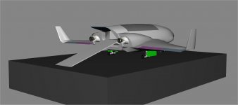
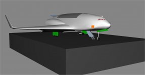
Progress on the Jason ll.
 

Attachments

  • Jasonll.jpg
    Jasonll.jpg
    45.6 KB · Views: 93
  • Jasonll2.jpg
    Jasonll2.jpg
    51.7 KB · Views: 81
Slowly progressing

starchaser3-angles.jpg


starchaser3.jpg
 
Back
Top