North Korean Sattelite Launch?

Urwumpe

Not funny anymore
Addon Developer
Donator
Joined
Feb 6, 2008
Messages
37,615
Reaction score
2,336
Points
203
Location
Wolfsburg
Preferred Pronouns
Sire
Yeah, it's pretty obvious they timed it to coincide with satellite overpasses. I hadn't realised it was timed with Worldview but if you look at the TLE there were two American and one Russian satellite above the Horizon at the rough time of the launch.

IMO that's pretty surprising considering their last one blew up so quickly after launch. They must've had quite a lot of confidence in their first stage to allow the world to see it so clearly.

Or they use the worldwide media for getting the engineering data, they are missing. Looking at the massive overexposure of the worldview CCDs right after staging (satellite comes from north), it seems like the staging was more than just hot.
 

simonpro

Beta Tester
Beta Tester
Joined
Feb 10, 2008
Messages
1,042
Reaction score
7
Points
0
That image is confusing me. The ground visible below the contrail doesn't match previous Worldview images from the area of North Korea between the launch site and the sea, I can't match it up at all.

(edit) Probably as it's over Japan, come to think of it. :D
(edit2) No, Im still confused. How come that website says the image was taken "102 minutes before the satellite ended up in sea-synchronous orbit"? 102 minutes before it hit the drink the satellite was still sitting on the launchpad.
 

cjp

Addon Developer
Addon Developer
Donator
Joined
Feb 7, 2008
Messages
856
Reaction score
0
Points
0
Location
West coast of Eurasia
(edit) Probably as it's over Japan, come to think of it. :D

Over Japan?
Then the rocket is already in a sort of horizontal flight.
Somehow the white shape isn't really aligned with the contrail. Maybe it is aligned with rows/columns in the CCD chip?
http://www.sc.eso.org/~ohainaut/ccd/CCD_artifacts.html
Then maybe the small white line on the top is the only 'real' part of the rocket in the image; the rest is just over-exposure.
 

rodion_herrera

Moonwatcher
Addon Developer
Joined
Nov 4, 2007
Messages
223
Reaction score
3
Points
18
Location
Muscat, Oman
Website
astronomicalsolutions.com
That image is confusing me. The ground visible below the contrail doesn't match previous Worldview images from the area of North Korea between the launch site and the sea, I can't match it up at all.

I found where it is when that shot was taken--and no it's not over Japan, it was still over the waters off the coast of NOKOR!...the problem is, the reported azimuth of the launch (90 [FONT=&quot]°[/FONT]?) then, is completely wrong!!!

First take a look at the purported satellite image:

musudan-ri_live_launch_dg_wv_090405-01.jpg


Now take a look at this terrain/area I found...
area_2.jpg


Matches, right? Now check this out...

main1.jpg


With A being the launch area...
area_1.jpg


Something's very fishy eh? If that alleged satellite photo above is really recent, doesn't that tell us that the missile was actually launched towards an azimuth of about 40 [FONT=&quot]°[/FONT] rather than 90 [FONT=&quot]°[/FONT]+ as the news bureau analysis maps (i.e. CNN, BBC) show us?

Anyone care to comment or correct me, if I'm mistaken?

NOTE: I just realized my mistake...I realized the rocket is not yet in horizontal flight...the sat image is an oblique shot (a good indicator of this is how the mountain peaks are "spilling" into the sea in the b/w satellite image, compared to the Google sat image), and thus the rocket may have in fact been heading towards 90.... I am stupid, please pardon my mistake. Still, I did find where that land mass is hehehe.

-RODION
 

cjp

Addon Developer
Addon Developer
Donator
Joined
Feb 7, 2008
Messages
856
Reaction score
0
Points
0
Location
West coast of Eurasia
Still, I did find where that land mass is hehehe.

Yes you did. Congratulations!

I couldn't find it in Japan, and I was already suspicious because there is a horizontal piece of ground in the image that isn't completely urbanized, and a river mouth that doesn't have a harbor. This can't be Japan.

So, what does this tell us?
The image contains incorrect information, but this won't fool the NK people. So, is this meant to fool us, or is it simply a mistake?

If the launch azimuth is really more northward, what does this say? Where would that bring the rocket? Looks like it goes north of Hokkaido, and actually closer to Russia. Why? Wasn't it an attempt to launch a satellite? Why not 90 degrees, if that's what you already prepared the world for?
 

rodion_herrera

Moonwatcher
Addon Developer
Joined
Nov 4, 2007
Messages
223
Reaction score
3
Points
18
Location
Muscat, Oman
Website
astronomicalsolutions.com
Yes you did. Congratulations!

I couldn't find it in Japan, and I was already suspicious because there is a horizontal piece of ground in the image that isn't completely urbanized, and a river mouth that doesn't have a harbor. This can't be Japan.

So, what does this tell us?
The image contains incorrect information, but this won't fool the NK people. So, is this meant to fool us, or is it simply a mistake?

LOL wait a sec, are you saying that my attempt to correct myself, was in fact, a mistake, and that this really IS a + or - 40 [FONT=&quot]° [/FONT]launch???

I wish an expert in satellite photos could shed light on this further--is the obliqueness and scale large enough to show the rocket in flight in a non-horizontal climb (and thus mean that the rocket was indeed headed + or - 90[FONT=&quot]° ) [/FONT]or is that all negligible, and what we are seeing is indeed in fact, a + or - 40 [FONT=&quot]° [/FONT]launch?

If the launch azimuth is really more northward, what does this say? Where would that bring the rocket? Looks like it goes north of Hokkaido, and actually closer to Russia. Why? Wasn't it an attempt to launch a satellite? Why not 90 degrees, if that's what you already prepared the world for?

As I've been saying in my Taepodong 1 Addon thread, I've been launching between azimuths 38-42 and they let me end up over Alaska and CONUS, provided the the third stage is fueled properly and doesn't weigh much.

-RODION
 

tblaxland

O-F Administrator
Administrator
Addon Developer
Webmaster
Joined
Jan 1, 2008
Messages
7,320
Reaction score
25
Points
113
Location
Sydney, Australia
So, what does this tell us?
The image contains incorrect information, but this won't fool the NK people. So, is this meant to fool us, or is it simply a mistake?

If the launch azimuth is really more northward, what does this say? Where would that bring the rocket? Looks like it goes north of Hokkaido, and actually closer to Russia. Why? Wasn't it an attempt to launch a satellite? Why not 90 degrees, if that's what you already prepared the world for?
I'd say the launch tracking info is pretty accurate and the launch azimuth was actually 90°. I don't see any reason to doubt those press release from the Japanese or the US.

As for the image itself, it could be an oblique angle, as suggested by rodion. The image shows an apparent track from north-west to south-east (southerly, away from Russia, not northerly that you said). Consider this sketch in Google Maps: http://maps.google.com.au/maps/ms?i...0.870949,129.71386&spn=0.187962,0.436363&z=12. I've shown the launch vehicle ground track for a 90° launch azimuth and a guestimated sight line between the Worldview-1 satellite (which would mostly be off screen somewhere) and the peninsula shown in the image. As rodion says, the angle is oblique and the forshortening of the cliffs appears consistent with the viewing angle I have shown, as does the apparent path of the vehicle.
 

rodion_herrera

Moonwatcher
Addon Developer
Joined
Nov 4, 2007
Messages
223
Reaction score
3
Points
18
Location
Muscat, Oman
Website
astronomicalsolutions.com
I'd say the launch tracking info is pretty accurate and the launch azimuth was actually 90°. I don't see any reason to doubt those press release from the Japanese or the US.

As for the image itself, it could be an oblique angle, as suggested by rodion. The image shows an apparent track from north-west to south-east (southerly, away from Russia, not northerly that you said). Consider this sketch in Google Maps: http://maps.google.com.au/maps/ms?i...0.870949,129.71386&spn=0.187962,0.436363&z=12. I've shown the launch vehicle ground track for a 90° launch azimuth and a guestimated sight line between the Worldview-1 satellite (which would mostly be off screen somewhere) and the peninsula shown in the image. As rodion says, the angle is oblique and the forshortening of the cliffs appears consistent with the viewing angle I have shown, as does the apparent path of the vehicle.

Whew! :) Ok yes that makes sense now. Always nice to have a 2nd op. :)

-RODION
 

cjp

Addon Developer
Addon Developer
Donator
Joined
Feb 7, 2008
Messages
856
Reaction score
0
Points
0
Location
West coast of Eurasia
LOL wait a sec, are you saying that my attempt to correct myself, was in fact, a mistake, and that this really IS a + or - 40 [FONT=&quot]° [/FONT]launch???
Ahem, I should have read your entire post, and think a bit more... :embarrassed:

The site in the picture is about 10km from the launch site. That is not much, compared to typical satellite altitudes. So I guess the rocket is still climbing a lot. My previous post probably contains nonsense (at least partially).

It should be possible to do some triangulation on the image, but you won't get complete information about the flight path from a single image. You'll probably get some kind of curved surface in which the flight path is located.
If you then assume the rocket doesn't yaw, and do some assumption on the launch location, then we might have the full 3D path (and hence the azimuth, and a lot of other information). Interesting challenge.
 

rodion_herrera

Moonwatcher
Addon Developer
Joined
Nov 4, 2007
Messages
223
Reaction score
3
Points
18
Location
Muscat, Oman
Website
astronomicalsolutions.com
Ahem, I should have read your entire post, and think a bit more... :embarrassed:

The site in the picture is about 10km from the launch site. That is not much, compared to typical satellite altitudes. So I guess the rocket is still climbing a lot. My previous post probably contains nonsense (at least partially).

It should be possible to do some triangulation on the image, but you won't get complete information about the flight path from a single image. You'll probably get some kind of curved surface in which the flight path is located.
If you then assume the rocket doesn't yaw, and do some assumption on the launch location, then we might have the full 3D path (and hence the azimuth, and a lot of other information). Interesting challenge.

Actually, this was the point of me doing the addon anyways, simply just to satisfy my own curiosity and answer some questions like this lol. Now all I have to do is beat my behind with a stick and finish a "workable" release, so that you guys can do some figuring out / experiments with it in Orbiter. :)

-RODION
 

rodion_herrera

Moonwatcher
Addon Developer
Joined
Nov 4, 2007
Messages
223
Reaction score
3
Points
18
Location
Muscat, Oman
Website
astronomicalsolutions.com
As for the image itself, it could be an oblique angle, as suggested by rodion. The image shows an apparent track from north-west to south-east (southerly, away from Russia, not northerly that you said). Consider this sketch in Google Maps: http://maps.google.com.au/maps/ms?i...0.870949,129.71386&spn=0.187962,0.436363&z=12. I've shown the launch vehicle ground track for a 90° launch azimuth and a guestimated sight line between the Worldview-1 satellite (which would mostly be off screen somewhere) and the peninsula shown in the image. As rodion says, the angle is oblique and the forshortening of the cliffs appears consistent with the viewing angle I have shown, as does the apparent path of the vehicle.

And here's proof! :) I tried launching at the exact same site, at exactly towards 90 deg azimuth, and voila...

correct.jpg
musudan-ri_live_launch_dg_wv_090405-01.jpg


Pretty close eh? I bet it's a perfect match if the photographing satellite was somewhere over the equator and looking "upwards" towards NO/SOKor--I wasn't really aiming for an exact angle, just a rough check if tblaxland's theory was right. And the neat thing was, staging occurred about 3-5 seconds right after I took that shot! :)

Oh btw, the alpha of my Taepodong 1 has been released!!! Please check this thread:

http://www.orbiter-forum.com/showthread.php?t=7373

-RODION
 

SiberianTiger

News Sifter
News Reporter
Donator
Joined
Feb 13, 2008
Messages
5,398
Reaction score
8
Points
0
Location
Khimki
Website
tigerofsiberia.livejournal.com
Rodion, you may want to try to reproduce acquiring the simulated image having the exact position of the Worldview-1's camera at the moment:

02:30:45 UTC
N38.5° E127.8°
Altitude ~500 km
 

rodion_herrera

Moonwatcher
Addon Developer
Joined
Nov 4, 2007
Messages
223
Reaction score
3
Points
18
Location
Muscat, Oman
Website
astronomicalsolutions.com
Rodion, you may want to try to reproduce acquiring the simulated image having the exact position of the Worldview-1's camera at the moment:

02:30:45 UTC
N38.5° E127.8°
Altitude ~500 km

Wish I could but have run out of time at the moment :( 
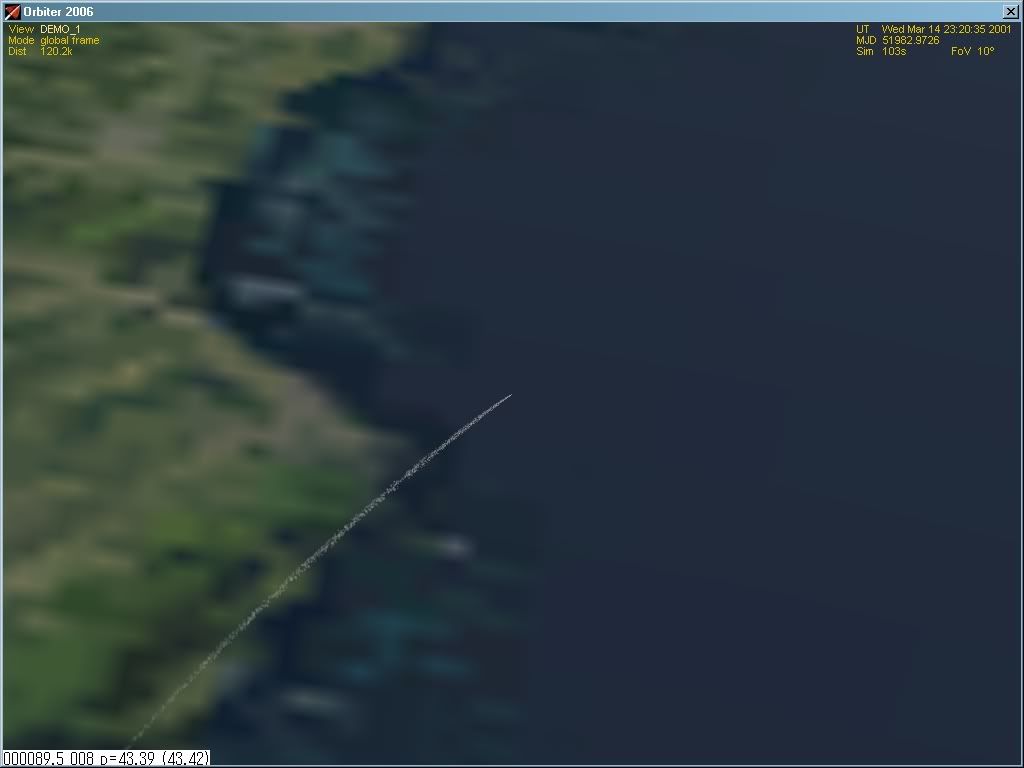
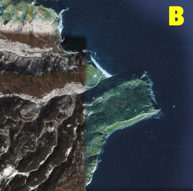
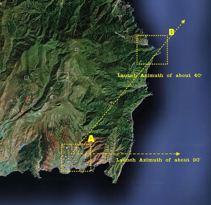
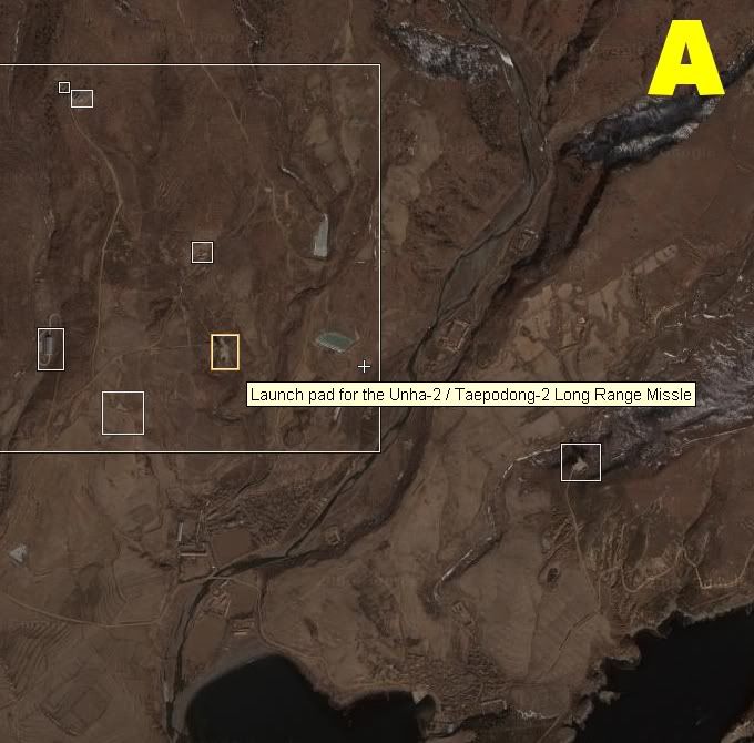
I had a small window in which to launch the alpha release of the addon (and take that quick snapshot)...I hope some of you guys can try this out yourselves, I mean SiberianTiger's suggestion and please post your resulting images here! Thank you!

38 deg N!!! I was wrong about the phrase "over the equator" then, apologies! :(

-RODION
 

Hielor

Defender of Truth
Donator
Beta Tester
Joined
May 30, 2008
Messages
5,580
Reaction score
2
Points
0
I'd say the launch tracking info is pretty accurate and the launch azimuth was actually 90°. I don't see any reason to doubt those press release from the Japanese or the US.

As for the image itself, it could be an oblique angle, as suggested by rodion. The image shows an apparent track from north-west to south-east (southerly, away from Russia, not northerly that you said). Consider this sketch in Google Maps: http://maps.google.com.au/maps/ms?i...0.870949,129.71386&spn=0.187962,0.436363&z=12. I've shown the launch vehicle ground track for a 90° launch azimuth and a guestimated sight line between the Worldview-1 satellite (which would mostly be off screen somewhere) and the peninsula shown in the image. As rodion says, the angle is oblique and the forshortening of the cliffs appears consistent with the viewing angle I have shown, as does the apparent path of the vehicle.

Not sure the view angle you gave is correct, since that would have it looking straight along the "flat" part of that peninsula, which is visibly slanted toward the left in the satellite image.

A telescreen transmission of the launch:
...
The animation is incorrect--it shows it successfully entering orbit, not crashing into the ocean as it actually did...
 

tblaxland

O-F Administrator
Administrator
Addon Developer
Webmaster
Joined
Jan 1, 2008
Messages
7,320
Reaction score
25
Points
113
Location
Sydney, Australia
Not sure the view angle you gave is correct, since that would have it looking straight along the "flat" part of that peninsula, which is visibly slanted toward the left in the satellite image.
You are right. When I made that position estimate I was more concerned about the north arrow that was shown in the linked WorldView-1 image. I have a high degree of confidence that it is incorrect, especially given the coordinates posted by ST.
 

Andy44

owner: Oil Creek Astronautix
Addon Developer
Joined
Nov 22, 2007
Messages
7,620
Reaction score
7
Points
113
Location
In the Mid-Atlantic states
Quote:
Originally Posted by SiberianTiger
A telescreen transmission of the launch:
...


The animation is incorrect--it shows it successfully entering orbit, not crashing into the ocean as it actually did...

Why do you hate Big Brother? Minitru is coming to visit.
 
Top