Soheil_Esy
Fazanavard فضانورد
- Joined
- Apr 5, 2015
- Messages
- 744
- Reaction score
- 19
- Points
- 18
Launch date: 2015 FEB 8-25 /07:00 - 12:00 (GMT+8:30)
Launcher: Unha-XX (은하)
Payload(Country): Kwangmyongsong (or Shining Star; 광명성) (DPRK)
Launch site(Country): Sohae(DPRK)
Launch pad: LC1
Status: Pending
Orbit type and parameter: SSO
Remark: XX
Notifications
- IMO and ITU
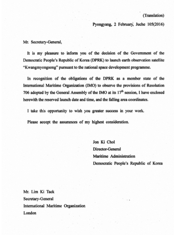
February 2, 2016
North Korea has begun informing international organizations of its intention to launch an earth observation satellite sometime between February 8 and 25.
The International Maritime Organization (IMO) in London said it had received notice of the launch and would be issuing an advisory to its members. Such notifications are commonplace for space launches or missile tests and serve as warnings to ships and aircraft to stay away from areas through which the rocket will fly or fall.
The launch notification named the satellite as “Kwangmyongsong,” (광명성) which is the same name given to previous satellites that were built by the country.
The International Telecommunications Union (ITU) said it had also received a notification. The letter, which came through the DPRK’s mission to the United Nations in New York, indicated the satellite would have a lifetime of 4 years.
Here’s the notification to the IMO:
http://www.northkoreatech.org/wp-content/uploads/2016/02/160202-imo-1.png
http://www.northkoreatech.org/wp-content/uploads/2016/02/160202-imo-2-570x720.png
http://www.northkoreatech.org/2016/02/02/dprk-signals-february-satellite-launch/
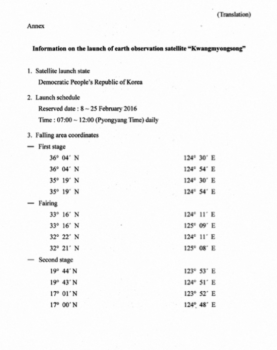
Launch notification reveals rocket drop zones
February 3, 2016
The launch notification sent on Tuesday by the DPRK to the International Maritime Organization warns of three areas that shipping should stay away from when the country conducts its planned satellite launch.
The launch is due to take place from Sohae satellite launch site sometime between February 8 and 25 between 7am and noon Pyongyang time. The three zones are the areas where the rocket’s first stage, fairing and second stage will drop back to sea.
The first stage is the lower part of the rocket and provides the power for the first minute or so of its flight. Once the fuel is used up, this detaches and falls back to earth. At that point the second stage engines fire up to take the satellite closer to space.
The fairing is the protective cover that sits around the satellite during the first part of its journey. Once the rocket gets high enough, the fairing is no longer needed and that too is jettisoned. Finally, the second stage engine cuts out and the rest of the rocket falls back to earth.
If all has gone according to plan, the satellite has been delivered to the right spot and continues its journey in orbit.
Here are the three areas on a map with Sohae launch site indicated at the top of the picture.

https://pbs.twimg.com/media/CaSKDhvUUAAsJjw.jpg
The zones are close but not identical to those used in launches in 2012.
The first stage is expected to land in the sea off the west coast of South Korea. That gives the South Korean Navy the chance to recover the rocket and see what they can learn about improvements in North Korean rocket technology.
The fairing will fall in a larger area off the south west coast of South Korea, closer to Jeju Island. This drop zone might be larger because the fairing is less aerodynamic and so its fall is more difficult to predict.

https://pbs.twimg.com/media/CaSKC_nVIAAGpxH.jpg
April 2012 splash downs in green, 2016 in yellow
And finally, the second stage rocket is expected to land in waters to the east of the Philippines. This is similar to a previous North Korean satellite launch and will disrupt air travel in the region.

http://oi68.tinypic.com/adjl6v.jpg
April 2012 splash downs in green, 2016 in yellow

https://pbs.twimg.com/media/CaOyOUOUUAAP-Kd.jpg
https://www.northkoreatech.org/2016/02/03/launch-notification-reveals-rocket-drop-zones/ - Navigational Warnings
NAVAREA XI
NO.16-0068 Date:2016/02/03 01 UTC
YELLOW SEA, EAST CHINA SEA AND
NORTH PACIFIC, LUZON.
DANGEROUS TO NAVIGATION AREA DESIGNATED
DUE TO ROCKET CARRIER ELEMENTS FALL.
2230Z TO 0330Z COMMENCING DAILY 07 TO 25
FEB. AREA BOUNDED BY
A. 36-04N 124-30E 36-04N 124-54E
35-19N 124-54E 35-19N 124-30E.
B. 33-16N 124-11E 33-16N 125-09E
32-21N 125-08E 32-22N 124-11E.
C. 19-44N 123-53E 19-43N 124-51E
17-00N 124-48E 17-01N 123-52E.
CANCEL THIS MSG 250430Z FEB.
Location map:

http://i68.tinypic.com/2yoq3ag.jpg
http://www1.kaiho.mlit.go.jp/TUHO/vpage/visualpage_en.html?type=212&tana=160068
http://www1.kaiho.mlit.go.jp/TUHO/keiho/cgi/disp_warnings.cgi?TYPE=NAVAREA11&TANA=160068&LANG=EG
February 3, 2016
A SK government source here said the likeliest date is former North Korean leader Kim Jong-il's birthday on Feb. 16.
...
The North announced the launch plan the very day when chief Chinese nuclear negotiator Wu Dawei was visiting Pyongyang.
http://english.chosun.com/site/data/html_dir/2016/02/03/2016020300944.html
February 2016 Holidays in North Korea
http://www.timeanddate.com/holidays/north-korea/Feb 8 Monday Chunjeol (춘절) / Spring Festival, Lunar New Year's Day Public Holiday
Feb 16 Tuesday Kwangmyongsong day ( 광명성절 ) / Day of Shining Star, Birth date of Kim Jong Il Public Holiday
Feb 22 Monday Cheongwoldaeboreum (정월대보름) / The 15th of the first month by the lunar calendar Public Holiday
Last edited by a moderator:
")