-
ORBITER-FORUM will be temporarily closed at 2026-07-23 18:00 UTC while we complete some OF maintenance tasks. The amount of downtime is expected to take up to one hour, but probably less.
You are using an out of date browser. It may not display this or other websites correctly.
You should upgrade or use an alternative browser.
You should upgrade or use an alternative browser.
Orbiter Screenshot Thread
- Thread starter Tex
- Start date
NASSP 8.0 alpha
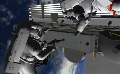
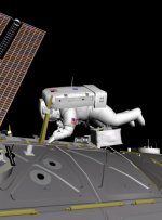
Apollo 14 flown with Virtual AGC running authentic AGC & LGC software.


Over-flying Descartes, the future Apollo 16 landing site:

Antares on the surface at Fra Mauro:

Rendez-vous with Kitty Hawk:


DSKY shows R1 of +00009, meaning 0.9 NM to the target:

Previously, launches were broken in Orbiter 2016. We have found some working touchdown points for the Saturn V and should reach orbit no problem as of now. Flying an entire mission is now possible in Orbiter 2016.
Note that we however are still working on finding working touchdown points for the Saturn 1B (Apollo 7).
Follow this link for the latest Alpha release of NASSP 8.0 for Orbiter 2016:
https://github.com/dseagrav/NASSP/releases
Apollo 14 flown with Virtual AGC running authentic AGC & LGC software.
Over-flying Descartes, the future Apollo 16 landing site:
Antares on the surface at Fra Mauro:
Rendez-vous with Kitty Hawk:
DSKY shows R1 of +00009, meaning 0.9 NM to the target:
Previously, launches were broken in Orbiter 2016. We have found some working touchdown points for the Saturn V and should reach orbit no problem as of now. Flying an entire mission is now possible in Orbiter 2016.
Note that we however are still working on finding working touchdown points for the Saturn 1B (Apollo 7).
Follow this link for the latest Alpha release of NASSP 8.0 for Orbiter 2016:
https://github.com/dseagrav/NASSP/releases
Last edited:
- Joined
- Feb 2, 2012
- Messages
- 1,664
- Reaction score
- 115
- Points
- 78
Previously, launches were broken in Orbiter 2016. We have found some working touchdown points for the Saturn V and should reach orbit no problem as of now. Flying an entire mission is now possible in Orbiter 2016.
Note that we however are still working on finding working touchdown points for the Saturn 1B (Apollo 7).
Hi Jalex, I've been working on touchdown points for a while and I think I've found a couple of formulas that can be used and works fine. Let me know if you need any help on that.

Hi Jalex, I've been working on touchdown points for a while and I think I've found a couple of formulas that can be used and works fine. Let me know if you need any help on that.
That would be great, Fred. We have found some touchdown points by trial and error for the Saturn V and LM, but they definitely need some fine tuning as the vehicles will sometimes tip over when changing views or during time acceleration. Your input we be greatly appreciated!
You can join the NASSP discussion on freenode.net with a client or:
https://webchat.freenode.net/ channel: #nassp
Last edited:
Astro SG Wise
Future Orion MPCV Pilot


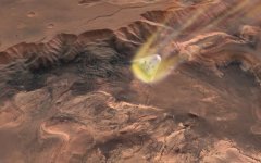
Here are a few early samplers of what keeps me busy at the moment: incorporating the Mars Express HRSC (high resolution stereo camera) data into the Mars elevation and surface textures.
For the surface textures I am currently only using the panchromatic images from the HRSC nadir camera. These have been used to pan-sharpen the artificially colourized MOC (Mars Orbiter camera) data that are used as a colour reference. The next step will be to incorporate the HRSC colour channels as well.
MOC (Orbiter 2016)

MOC+HRSC (current development status)

MOC (Orbiter 2016)

MOC+HRSC (current development status)

Generating the mosaics from the individual HRSC fragments is a fairly elaborate number-crunching effort because of the sheer amount of data. Once I've tested the final processing pipeline it will probably have to run for a couple of weeks to generate the global map. I hope it's going to be worth it ...
For the surface textures I am currently only using the panchromatic images from the HRSC nadir camera. These have been used to pan-sharpen the artificially colourized MOC (Mars Orbiter camera) data that are used as a colour reference. The next step will be to incorporate the HRSC colour channels as well.
MOC (Orbiter 2016)
MOC+HRSC (current development status)
MOC (Orbiter 2016)
MOC+HRSC (current development status)
Generating the mosaics from the individual HRSC fragments is a fairly elaborate number-crunching effort because of the sheer amount of data. Once I've tested the final processing pipeline it will probably have to run for a couple of weeks to generate the global map. I hope it's going to be worth it ...
boogabooga
Bug Crusher
- Joined
- Apr 16, 2011
- Messages
- 3,006
- Reaction score
- 16
- Points
- 63
Orbiter 2016 is reaching the threshold of not being able to tell screenshot from photo.
- Joined
- Feb 4, 2008
- Messages
- 9,758
- Reaction score
- 1,028
- Points
- 203
Once I've tested the final processing pipeline it will probably have to run for a couple of weeks to generate the global map. I hope it's going to be worth it ...
If the result looks anywhere near to those screenshots, then I'd say yes, it's gonna be worth it. I have tried to describe the two posted screenshots without using expletives, and failed miserably.
Do you have the necessary hardware freely available? Donation efforts for orbiter don't make much sense in most cases, but a few guys putting some money together to rent an amazon EC2 server for a month or two so you don't have to block your own hardware with such a process would sound like a sensible thing.
Thanks for the offer. I should be ok though. I can probably quietly use I slightly underused machine at work (128GB RAM, 32 cores, my favourite Linux box
") ). The problem with sharing out the workload is distributing the data. I've got about 1.5TB of HRSC source data at the moment, and that's only the level-4 processed images. If I decide to also include level-3 to improve coverage, it will be much more. And it wouldn't be trivial to partition the data into local chunks.
). The problem with sharing out the workload is distributing the data. I've got about 1.5TB of HRSC source data at the moment, and that's only the level-4 processed images. If I decide to also include level-3 to improve coverage, it will be much more. And it wouldn't be trivial to partition the data into local chunks.- Joined
- Feb 6, 2008
- Messages
- 38,938
- Reaction score
- 3,937
- Points
- 203
- Location
- Wolfsburg
- Preferred Pronouns
- Sire
And it wouldn't be trivial to partition the data into local chunks.
Oh yes. :lol: Especially depending on the overlaps of the different sensors.
I've got about 1.5TB of HRSC source data at the moment
Holy... How large is that final texture archive going to be? :blink:
Also, just made the "litmus test" with my wife. She totally thought that screenshot was an actual photograph of Mars.
And a short OT question to you martins, since you're hanging around at the moment: WHat library did you use in Orbiter to talk to LUA? I'm currently contemplating putting a LUA interface in my add-on and am looking at potential binding libraries.
Last edited:
Holy... How large is that final texture archive going to be? :blink:
I am planning a global level 12 texture, plus local level 13 or 14 "scenic hotspots". The final size will probably be similar to the current Earth textures (which are level 13 globally for land areas, much lower for oceans)
On Mars, level 12 corresponds to a resolution of about 80 metres at the equator.
The HRSC images have a nominal resolution of 12.5m for the nadir camera, and 50m for the colour channels and the computed elevation data. The true resolution can be lower than that, depending on the orbit altitude.
- Joined
- Feb 4, 2008
- Messages
- 9,758
- Reaction score
- 1,028
- Points
- 203
On the opposite end from my last screenshot. D3D9Client has come quite far. https://www.dropbox.com/s/aewyigh1ut0m67q/SSU_sunset_D3D9Client_R2.jpg?dl=0
Another update:
This is a scene where the HRSC nadir channel is used to pan-sharpen the colourised MOC data (corresponding to the MOC+HRSC images in my previous post):

This is the same scene, now using the nadir channel to pan-sharpen the actual HRSC colour channels, before low frequency-matching them to the MOC colour reference:

The HRSC colour data definitely make the scene more dramatic (and hopefully provide higher frequency colour information), not to mention replacing fake colour data with real ones (at least at high spatial freqencies).
I noticed some slight striping artefacts in the HRSC colour channels, but hopefully they won't be apparent close up in Orbiter. At the lower resolution levels I might gradually fade out the HRSC colours.
I've got one more idea up my sleeve I want to try before starting on the global mosaic in earnest: Currently I am matching the low resolution colour reference by rescaling the low freqency band of the RGB channels to match the means of the reference. While this matches the mean intensity, it doesn't match the contrast. This can be a problem if the brightness difference between HRSC fragment and reference data is high. For example, if the HRSC sample is much darker than the reference, rescaling the means might lead to a much higher contrast than the reference.
To address this, I am going to try to match the low-frequency variance as well as the mean. This would match variance multiplicatively, and mean additively. Of course, this operation might subdue the drama of the above scene, so I'll have to see how it looks. Anyway, worth a try.
This is a scene where the HRSC nadir channel is used to pan-sharpen the colourised MOC data (corresponding to the MOC+HRSC images in my previous post):
This is the same scene, now using the nadir channel to pan-sharpen the actual HRSC colour channels, before low frequency-matching them to the MOC colour reference:
The HRSC colour data definitely make the scene more dramatic (and hopefully provide higher frequency colour information), not to mention replacing fake colour data with real ones (at least at high spatial freqencies).
I noticed some slight striping artefacts in the HRSC colour channels, but hopefully they won't be apparent close up in Orbiter. At the lower resolution levels I might gradually fade out the HRSC colours.
I've got one more idea up my sleeve I want to try before starting on the global mosaic in earnest: Currently I am matching the low resolution colour reference by rescaling the low freqency band of the RGB channels to match the means of the reference. While this matches the mean intensity, it doesn't match the contrast. This can be a problem if the brightness difference between HRSC fragment and reference data is high. For example, if the HRSC sample is much darker than the reference, rescaling the means might lead to a much higher contrast than the reference.
To address this, I am going to try to match the low-frequency variance as well as the mean. This would match variance multiplicatively, and mean additively. Of course, this operation might subdue the drama of the above scene, so I'll have to see how it looks. Anyway, worth a try.
Is that one of your meshes Don?
Similar threads
- Replies
- 7
- Views
- 4K
- Replies
- 1
- Views
- 5K
- Replies
- 12
- Views
- 5K
- Replies
- 10
- Views
- 4K