I have asked myself the same question: How did Martin Schweiger create the high resolution textures and the night lights in particular and how could they be upgraded with more recent and possibly better data (and I also want to add some kind of basic auroral oval to it). It has been quite the rabbit hole to go into and more questions than answers have come up for me. Making global high resolution maps is some pretty sophisticated stuff even for someone who works with satellite data every day.
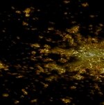
Firstly, the Blue Marble night lights made from VIIRS data only have a resolution of 750 meters/pixel because that is the resolution of the sensor. To my knowledge there has never been any public Earth at night data better than that. I'm not sure what data was used to create the Orbiter night light textures but it's clear to me, that whatever was used was combined most probably with Landsat data by some algorithm. It's a clever idea but it's not perfect and it created some weird results because in Orbiter it seems that sometimes things like fields are lit up brightly while other areas even within cities are completely dark like in this view of Denver:
.jpg")
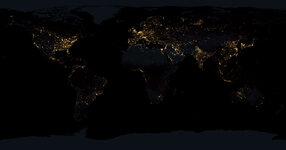
It still gives not too bad an appearance and it seems to be at a quite high resolution, but then there's also areas not covered by night lights at all like northern Europe. It got me thinking what other ways might be feasible to make a new, maybe more realistic map. The available data is limited such that the result will always be some kind of compromise, but I thought it could be an interesting approach to use the Blue Marble night lights as a brightness and colour mask (works best if you blur it a little bit) for high resolution satellite imagery - in this case I used 10 m Sentinel 2 mosaic data scaled down to 75 meter resolution to make it less of a pain to work with. It would be enough to create a level 13 global map. That's unfortunately a lot of pixels.
I think the result is quite convincing though - not perfect either but imho it looks a bit more realistic.

More detail (it's Berlin btw):

But there is still a catch:
Doing that on a global scale again is a big task, especially when aiming at anything higher than a level 11 map. If you haven't got lots of disk space and computing power at hand it's almost impossible and even if this can be automated to a great degree, it will probably take a long time.
I think the most difficult to avoid bottleneck in this case is that I created this with a few not exactly trivial operations in Photoshop and while it is possible to do batch operations in Photoshop, I'm not sure it will help much in this case.
Then I'm also struggling to find an easily accessible data source for the high resolution satellite imagery and even after hours of searching the internet, I can't find easily accessible global high resolution (daylight) imagery that would enable me to make a global map like that within a comfortable amount of time because the biggest problem (for a change) is mostly too much resolution. Yup.
The best quality source that I found so far is a global Sentinel 2 (mostly) cloudfree mosaic, but you can currently only download it at full 10 m resolution in 5° x 5° raw data tiles. So even if you ignore most of the oceans (although there is a lot of lights in the ocean as well, like oil rigs, wind farms etc.) there is something between 1000-2000 individual tiles to process in the form of 10 m resolution 16 bit tiff raw data. That obviously is not doable for a single person with a standard PC as it's on the order of several TB worth of data. There seems to be a 120 meter Sentinel 2 mosaic somewhere but I haven't found a way to download it. I'm currently trying to use qgis and a few other tools and apis that I'm currently investigating (but unfortunately it's quite messy as well and I'm running into all kinds of weird problems) but maybe someone reading this has any idea how to easily get access to an easy to work with intermediate-high resolution global Landsat or Sentinel dataset with around 80-160 m downloadable resolution. That would be awesome.
I unpacked the mask.tree file to investigate it a bit and it's a bit funny that it contains up to level 19 textures that clearly are just upscaled by simple interpolation (which of course still makes some sense to reduce the appearance of sharp blocks). The highest resolution in terms of more information seems to be level 13, after that it's just interpolated. But still, level 13 is very high resolution in terms of image processing on a global scale. It equates to 80 m/pixel.
As another update I managed to get access to the Sentinel 2 120m mosaics, but it's the same problem, it's basically raw data and it's near impossible to process on a local machine. I'll have to think again which of the few extremely complicated ways would be the most promising, but this certainly is a disappointment.


 that's relieving! On the other hand it would save me a lot of work.


 . My favourite one is that with a saw in the head. I'm starting to feel the same. It's probably going to be weeks before I complete the new map, because it's a lot of tiles to work on for level 12 and I think there might be problems ahead that I'm not even aware of yet. Even if you know exactly how to do it and work like a robot it's a pain. But I'm still looking forward to the result, so I'm not stopping.
 ")


