The Copernicus Programme, the flagship Earth observation satellite program of the European Space Agency and the European Commission, is about to receive their second satellite into operation.
While the first one, Sentinel 1A, concerns radar observation of our Earth's surface, Sentinel 2A goes for the most recognizable method of mapping out planet from space - optical observation.
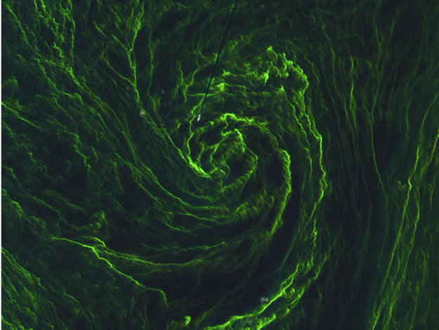
The Sentinel 2 series is Europe's newest counterpart to the "king of EO satellites" - the Landsat program of the United States - especially mirroring and complementing the abilities of the newest member, Landsat 8. While they are not going for high resolutions like many other satellites do, their power lies with wider image swaths and more spectral bands for dozen meter resolution class images. These general purpose EO satellites are very useful in a large number of usages, especially when doing general geological and land usage analysis of a certain region and monitoring changes in vegetation, oceans and forests. What makes Sentinel 2 stands out from Landsat is that it will have 2 working at the same time for faster re-visiting (with Sentinel 2B going up next year) and more mapping bands all the way into near-infrared.
Sentinel 2A is now ready for launch on the 5th Vega rocket to fly, and the 2nd to fly this year. The trip to orbit starts in just less than 8 hours from now. :tiphat:


Launch location:
Kourou ELV 5°14'9"N 52°46'30"W

Launch dates and times:
[table="head"]{colsp=7}Launch times
{colsp=7}[highlight]
Live Coverage


PAYLOAD
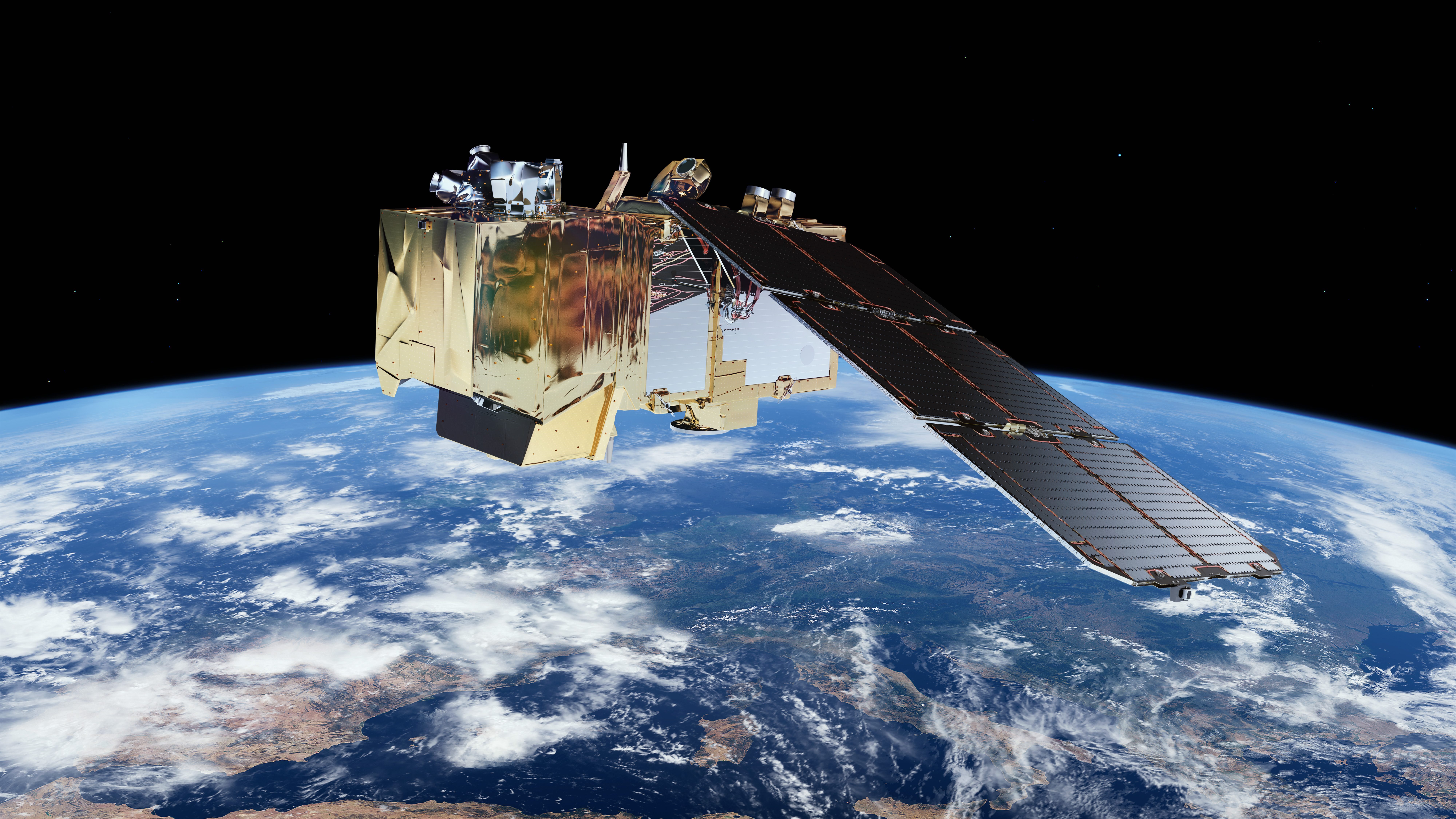
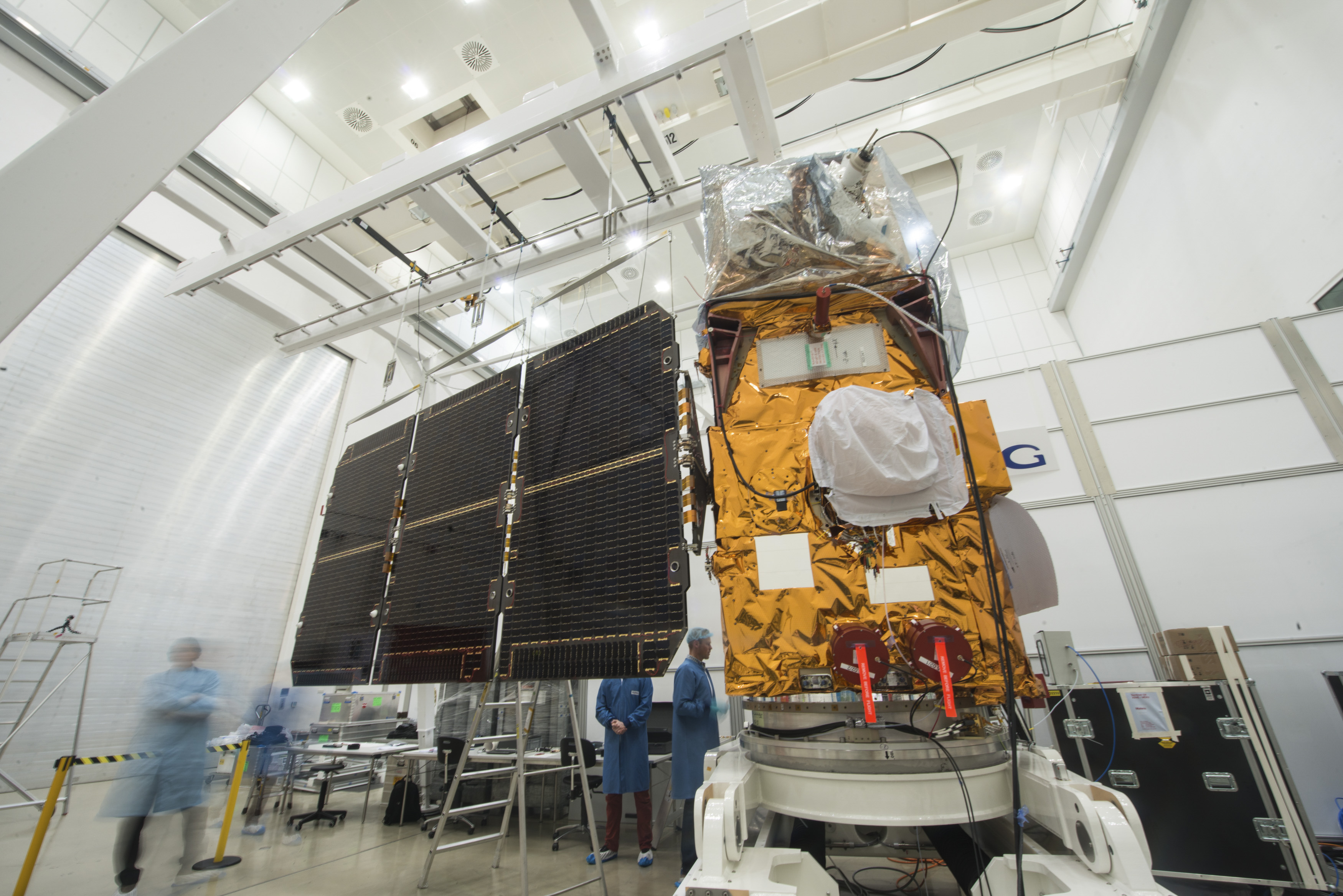
Sentinel 2A optical Earth observation satellite
The European Space Agency and Astrium signed in April 2008 a €195 million contract to provide the first Sentinel-2 Earth observation satellite, devoted to monitoring the land environment, as part of the European GMES programme. As prime contractor, Astrium is responsible for the design, development and integration of the satellite, which will perform a high-end multi-spectral optical imaging mission.
Global Monitoring for Environment and Security (GMES) aims to deliver environment and security services and is being led by the European Commission. It is the European response to the ever-increasing demands of effective environmental policies. At the same time, it is the European contribution to the Global Earth Observation System of Systems (GEOSS).
ESA is responsible for implementation of the GMES Space Component, a set of Earth observation missions involving ESA, EU/ESA Member States and other partners. Central elements of the Space Component are the five families of Sentinel missions.
Sentinel-2 will deliver crucial data for information services to the EU and its Member States under GMES. The services fed by it cover areas such as climate change, sustainable development, environmental policies, European civil protection, common agricultural policy, development aid, humanitarian aid and the Common Foreign & Security Policy.
Sentinel-2 will support the operational generation of products such as the mapping of land cover, land use, change detection and geophysical variables. The mission objective is systematic coverage of the earth's land surface (from -56° to +83° latitude) to produce cloud-free imagery typically every 15 to 30 days over Europe.
Sentinel-2 features a 290 km-wide coverage, 10-20 m spatial resolution, 13 optical channel instrument (operating from visible-near infrared to shortwave infrared) and will ensure enhanced-quality continuity with existing missions SPOT and Landsat. It will provide improved revisit time, swath width, coverage area, spectral bands, calibration and image quality. These features will enable it to contribute effectively to GMES needs for operational land and emergency services.
ESA carried out the Sentinel-2 definition phase over 2005/2006. The implementation phase started in October 2007. The launch of the first Sentinel-2 satellite is planned for October 2012. At a later stage, a second Sentinel-2 satellite is planned to increase the revisit rate.
The industrial consortium led by Astrium-GmbH (platform and satellite prime) includes a number of core-team partners: Astrium SAS is responsible for the payload instrument and system support activities; Boostec (F) is providing the three-mirror Silicon carbide telescope; CASA (E) is responsible for satellite structural and thermal activities; Jena-Optronik (D) is responsible for the instrument electrical architecture including video signal processing and data compression; Sener (E) is supplying the instrument calibration and shutter mechanism.
In December 2009 ESA signed a contract for a duplicate second spacecraft called Sentinel 2B.
[table="head"]{colsp=2}Characteristics
|[table="head"]{colsp=2}

[/table]
|
[/table]

Launch Vehicle:
[table="head"]{colsp=2}Characteristics
 |[table="head"]{colsp=2}
[/table]
[/table]
The launch vehicle's reliability standings (according to http://www.spacelaunchreport.com/log2014.html#rate):


Ascent profile


Weather Forecast for Kourou, French Guiana on June 22, 2015 (11 p.m.)
Scattered thunderstorms early, then mainly cloudy overnight with thunderstorms likely. Low 23C. Winds light and variable. Chance of rain 80%.
Time|Temps|Dew Point|Relative Humidity|Precip|Snow|Cloud cover|Pressure|Wind|Weather
11 PM|25°C|23°C|89%|35%|0%|50%|1016 hPa|5 km/h E|
 Chance of a Thunderstorm
References
http://www.arianespace.com
http://www.esa.int/Our_Activities/Observing_the_Earth/Copernicus/Sentinel-2/
https://directory.eoportal.org/web/eoportal/satellite-missions/c-missions/copernicus-sentinel-2
https://sentinels.copernicus.eu/web/sentinel/missions/sentinel-2
http://space.skyrocket.de/doc_sdat/sentinel-2.htm
http://www.csgpreparationlancement.com/
http://forum.nasaspaceflight.com
http://www.novosti-kosmonavtiki.ru
http://astronautique.actifforum.com
http://www.spacelaunchreport.com
http://www.esa.int/Our_Activities/Launchers/Launch_vehicles/Vega2
http://english.wunderground.com/cgi-bin/findweather/getForecast?query=zmw:00000.1.81403
While the first one, Sentinel 1A, concerns radar observation of our Earth's surface, Sentinel 2A goes for the most recognizable method of mapping out planet from space - optical observation.
The Sentinel 2 series is Europe's newest counterpart to the "king of EO satellites" - the Landsat program of the United States - especially mirroring and complementing the abilities of the newest member, Landsat 8. While they are not going for high resolutions like many other satellites do, their power lies with wider image swaths and more spectral bands for dozen meter resolution class images. These general purpose EO satellites are very useful in a large number of usages, especially when doing general geological and land usage analysis of a certain region and monitoring changes in vegetation, oceans and forests. What makes Sentinel 2 stands out from Landsat is that it will have 2 working at the same time for faster re-visiting (with Sentinel 2B going up next year) and more mapping bands all the way into near-infrared.
Sentinel 2A is now ready for launch on the 5th Vega rocket to fly, and the 2nd to fly this year. The trip to orbit starts in just less than 8 hours from now. :tiphat:
Launch location:
Kourou ELV 5°14'9"N 52°46'30"W
Launch dates and times:
[table="head"]{colsp=7}Launch times
Time Zone|Australia - Sydney/AEST|CEDT UTC+2|Universal / UTC|French Guiana / UTC-3
|Washington / EDT|Los Angeles / PDTLaunch time:|11:51:58|03:51:58|01:51:58|22:51:58|21:51:58|18:51:58
on:|Jun. 23, 2015|Jun. 23, 2015|Jun. 23, 2015|Jun. 22, 2015|Jun. 22, 2015|Jun. 22, 2015
on:|Jun. 23, 2015|Jun. 23, 2015|Jun. 23, 2015|Jun. 22, 2015|Jun. 22, 2015|Jun. 22, 2015
{colsp=7}[highlight]
[eventTimer]2015-06-23 01:51:58?before|after;%dd% Days %hh% Hours %mm% Minutes %ss% Seconds %c%[/eventTimer] Sentinel 2A Launch[/highlight]
[/table]Live Coverage
- http://www.arianespace.tv/ - begins 20 minutes before the launch
PAYLOAD
Sentinel 2A optical Earth observation satellite
The European Space Agency and Astrium signed in April 2008 a €195 million contract to provide the first Sentinel-2 Earth observation satellite, devoted to monitoring the land environment, as part of the European GMES programme. As prime contractor, Astrium is responsible for the design, development and integration of the satellite, which will perform a high-end multi-spectral optical imaging mission.
Global Monitoring for Environment and Security (GMES) aims to deliver environment and security services and is being led by the European Commission. It is the European response to the ever-increasing demands of effective environmental policies. At the same time, it is the European contribution to the Global Earth Observation System of Systems (GEOSS).
ESA is responsible for implementation of the GMES Space Component, a set of Earth observation missions involving ESA, EU/ESA Member States and other partners. Central elements of the Space Component are the five families of Sentinel missions.
Sentinel-2 will deliver crucial data for information services to the EU and its Member States under GMES. The services fed by it cover areas such as climate change, sustainable development, environmental policies, European civil protection, common agricultural policy, development aid, humanitarian aid and the Common Foreign & Security Policy.
Sentinel-2 will support the operational generation of products such as the mapping of land cover, land use, change detection and geophysical variables. The mission objective is systematic coverage of the earth's land surface (from -56° to +83° latitude) to produce cloud-free imagery typically every 15 to 30 days over Europe.
Sentinel-2 features a 290 km-wide coverage, 10-20 m spatial resolution, 13 optical channel instrument (operating from visible-near infrared to shortwave infrared) and will ensure enhanced-quality continuity with existing missions SPOT and Landsat. It will provide improved revisit time, swath width, coverage area, spectral bands, calibration and image quality. These features will enable it to contribute effectively to GMES needs for operational land and emergency services.
ESA carried out the Sentinel-2 definition phase over 2005/2006. The implementation phase started in October 2007. The launch of the first Sentinel-2 satellite is planned for October 2012. At a later stage, a second Sentinel-2 satellite is planned to increase the revisit rate.
The industrial consortium led by Astrium-GmbH (platform and satellite prime) includes a number of core-team partners: Astrium SAS is responsible for the payload instrument and system support activities; Boostec (F) is providing the three-mirror Silicon carbide telescope; CASA (E) is responsible for satellite structural and thermal activities; Jena-Optronik (D) is responsible for the instrument electrical architecture including video signal processing and data compression; Sener (E) is supplying the instrument calibration and shutter mechanism.
In December 2009 ESA signed a contract for a duplicate second spacecraft called Sentinel 2B.
[table="head"]{colsp=2}Characteristics
|[table="head"]{colsp=2}
Sentinel 2A
Prime contractor:
|Airbus Defence and Space
Mass at Separation:
|- 1130 kg
Stabilization:
|- 3 axis stabilized
Dimensions:
|- 3.3 x 2.3 x 1.7 m
Power:
|- 1.73 kW at end of life
Life time:
|- 7.25 years (with enough fuel for 12 years of operations)
Instruments:
|- Multispectral imager (MSI)
Orbit:
|- 786 km circular SSO, inclination 98.5°
[/table]
|
[/table]
Launch Vehicle:
[table="head"]{colsp=2}Characteristics
Vega
Prime contractor:
|- Avio

Height:
| 29.9 m with upper stage and payload fairingDiameter:
| max 3.025 mLiftoff mass:
| 137 metric tonnesPayload mass:
| ~1.5 tonnes at SSO (700 km, 90° inc.)First stage:
|- 1 X P80FW Solid Rocket Motor (SRM)
- Empty 7.43 tonnes
- Propellants 88.36 tonnes (HTPB)
- Thrust at sea level 2261 kN
- Vacuum specific impulse 280 s
Second stage:
|- 1 X ZEFIRO 23 Solid Rocket Motor
- Empty 1.84 tonnes
- Propellants 23.91 tonnes (HTPB)
- Thrust at sea level 1196 kN
- Vacuum specific impulse 289 s
Third stage:
|- 1 X ZEFIRO 9 Solid Rocket Motor
- Empty 0.83 tonnes
- Propellants 10.12 tonnes (HTPB)
- Thrust at vacuum 225 kN
- Vacuum specific impulse 295 s
Fourth stage (AVUM):
|- 1 X RD-869 engine
- Empty 0.42 tonnes
- Propellants 0.55 tonnes (UDMH/N2O4)
- Thrust at vacuum 2.45 kN
- Vacuum specific impulse 315.5 s
Payload Fairing:
|- Diameter 2.6 m
- Length 7.88 m
- Mass 490 kg
[/table]
[/table]
The launch vehicle's reliability standings (according to http://www.spacelaunchreport.com/log2014.html#rate):
Code:
================================================================
Vehicle     Successes/Tries Realzd Pred  Consc. Last     Dates
                             Rate  Rate* Succes Fail
================================================================
Vega               2     2   1.00  .75      2    None     2012-
Ascent profile
Weather Forecast for Kourou, French Guiana on June 22, 2015 (11 p.m.)
Scattered thunderstorms early, then mainly cloudy overnight with thunderstorms likely. Low 23C. Winds light and variable. Chance of rain 80%.
11 PM|25°C|23°C|89%|35%|0%|50%|1016 hPa|5 km/h E|
References
http://www.arianespace.com
http://www.esa.int/Our_Activities/Observing_the_Earth/Copernicus/Sentinel-2/
https://directory.eoportal.org/web/eoportal/satellite-missions/c-missions/copernicus-sentinel-2
https://sentinels.copernicus.eu/web/sentinel/missions/sentinel-2
http://space.skyrocket.de/doc_sdat/sentinel-2.htm
http://www.csgpreparationlancement.com/
http://forum.nasaspaceflight.com
http://www.novosti-kosmonavtiki.ru
http://astronautique.actifforum.com
http://www.spacelaunchreport.com
http://www.esa.int/Our_Activities/Launchers/Launch_vehicles/Vega2
http://english.wunderground.com/cgi-bin/findweather/getForecast?query=zmw:00000.1.81403
Last edited: