News Small local Tsunami after Mag 7.9 earthquake offshore Alaska

Urwumpe

Not funny anymore
Addon Developer
Donator
Joined
Feb 6, 2008
Messages
38,965
Reaction score
3,937
Points
203
Location
Wolfsburg
Preferred Pronouns
Sire
Stay safe!

https://earthquake.usgs.gov/earthquakes/eventpage/us2000cmy3#executive

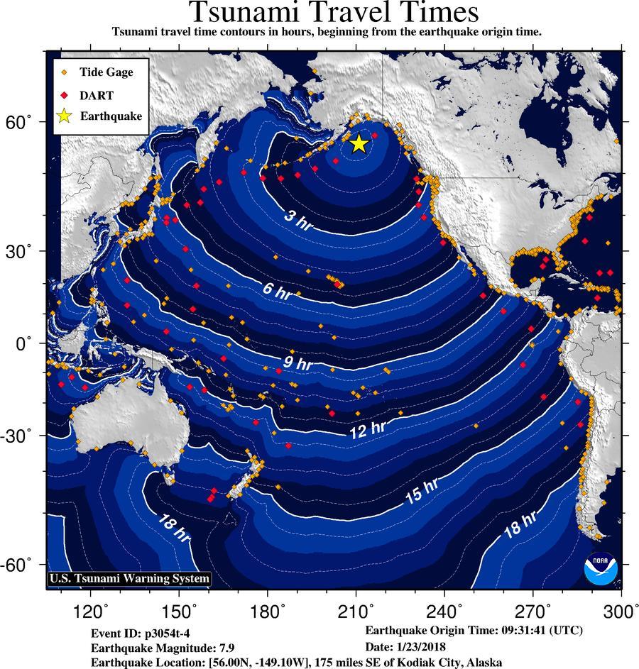
The quake itself is far away from any settlements and barely felt, but there are reports about a potential Tsunami. The US Tsunami warning system page is a bit slashdotted right now.

The beachball plot looks like it was mostly a slip fault with a tiny bit of thrust, so there are good chances the earthquake itself was not causing a strong tsunami. But until the first buoys report, its too early to exclude.
 
Last edited:
Hawaii watch now cancelled.

Kodiak Police now reporting water receding which isn't good.
 
The travel times as predicted by the NTWC:

DUOMO-xWsAAOEMk.jpg


---------- Post added at 12:48 ---------- Previous post was at 12:46 ----------

Sadly I can't access the DART buoy data, because the US government is shutdown. Thank you Trump.

---------- Post added at 14:06 ---------- Previous post was at 12:48 ----------

Looks like this won't be an issue anymore:

Code:
OBSERVATIONS OF TSUNAMI ACTIVITY - UPDATED
------------------------------------------
 * Observed max tsunami height is the highest recorded water level
   above the tide level up to the time of this message.

                                  TIME               OBSERVED MAX
 SITE                         OF MEASUREMENT         TSUNAMI HEIGHT
 ---------------------------- ----------------       --------------
 Kodiak  Alaska               0329  PST Jan 23           0.6ft
 Seward  Alaska               0331  PST Jan 23           0.4ft
 Old Harbor  Alaska           0338  PST Jan 23           0.7ft
 Sitka  Alaska                0318  PST Jan 23           0.4ft
 Yakutat  Alaska              0335  PST Jan 23           0.5ft
 Langara  BC                  0330  PST Jan 23           0.4ft
 
https://earthquake.usgs.gov/earthquakes/eventpage/us2000cmy3#moment-tensor

Looks like it was more or less strike-slip.
61e3a99f-bd4f-42af-a7f7-45e5e0cb4c2f


****************************

I was able to access the data and all related NOAA/USGS monitoring networks just fine this morning :hmm:

The only difference was that a note at the top of the page mentioned that some featured might not work due to the shutdown, but that forecasting and monitoring were fully funitional.

***************************
EDIT 2:

There did seem to be server problems with the official tsunami warning status page, but I felt it was related to visitor traffic, and I had to keep reloading it until it loaded without errors.
 
Last edited:
www.bbc.co.uk/news/uk-wales-south-east-wales-42803111

People in high-risk tsunami areas could soon be helped by an early-warning alarm system using sound waves that is being developed by scientists.
Mathematicians think they have devised a way of calculating the size and force of a tsunami in advance of it hitting land, which can help early detection.
Experts say naturally occurring high-speed acoustic gravity waves are created after "tsunami trigger events".
 

Can you point me to info on how to read those moment tensors, or the whole technical page for those quakes?


... Found this: https://lithics.wordpress.com/2012/04/13/how-to-read-a-moment-tensor-solution/

So basically if it looks like a crash dummy circle (two light quadrants, two dark) it's a strike slip (i.e. plates sliding laterally), and if it's more 'eye' shaped with light middle then the ground dropped (plates pulling apart), and if eye shaped with dark middle, then the ground was thrust upwards (plates pressing together). Did I get that right?
 
Last edited:
Back
Top