Soheil_Esy
Fazanavard فضانورد
- Joined
- Apr 5, 2015
- Messages
- 744
- Reaction score
- 20
- Points
- 18
Saturday, October 10, 2015
Larger JPG image
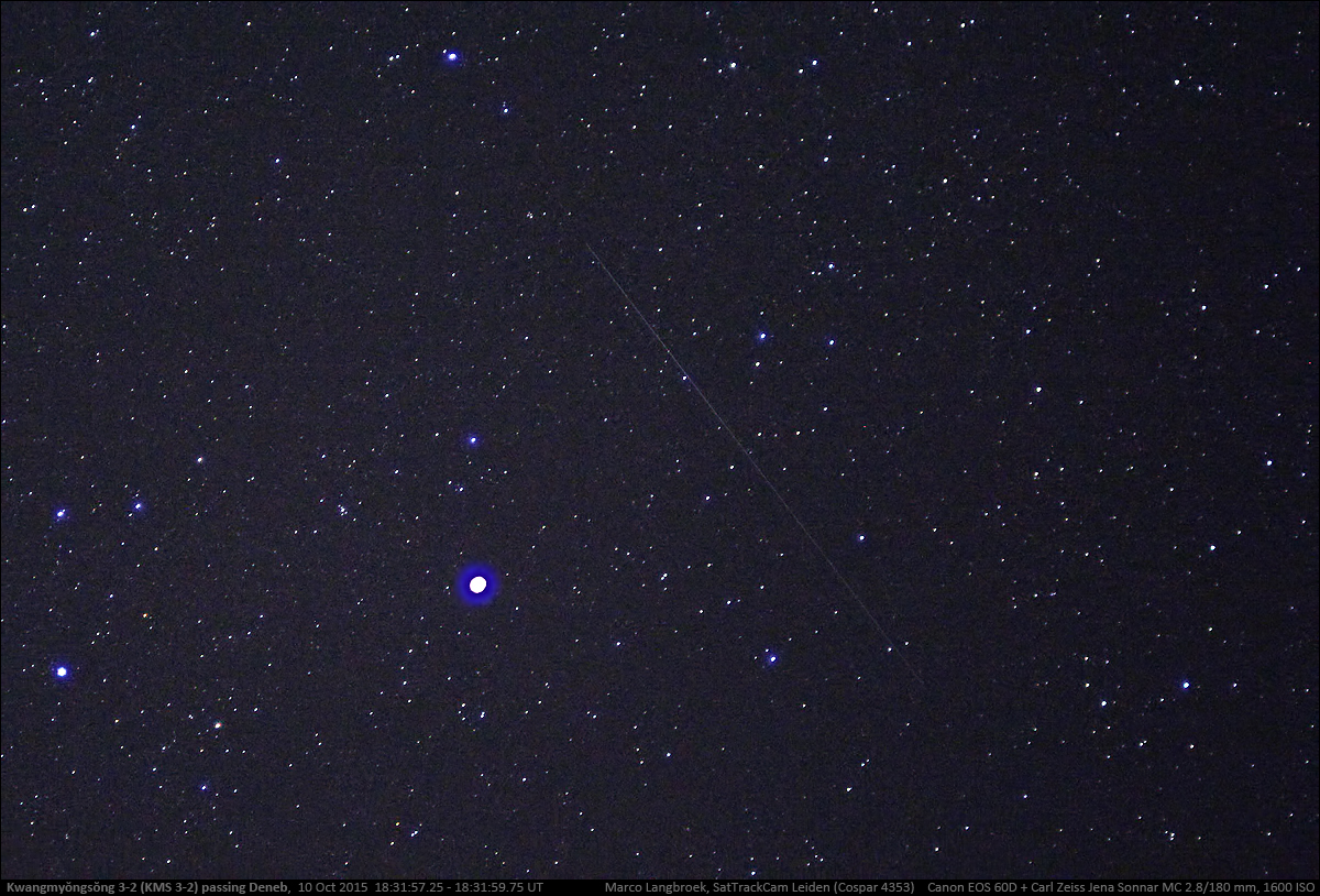
Kwangmyŏngsŏng-3 (KMS 3-2) passing Deneb, evening of 10 Oct 2015
UPDATE (11 Oct 2015):
I imaged Kwangmyŏngsŏng-3 again the next evening (image above), 10 Oct 2015 near 18:32 UT, when it passed the bright star Deneb (brightest star in image). This time I used the Zeiss Sonnar MC 2.8/180mm lens, which shows fainter objects but has an even smaller FOV. The trail is faint but shows up well
Larger JPG image
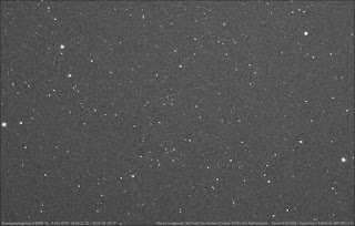
Kwangmyŏngsŏng-3 (KMS 3-2), evening 9 Oct 2015
[original post before update:] Yesterday evening started clear. While my targets for that evening were the payloads of the NROL-55 launch from October 8 (more on that in a later post), I took the opportunity to image a pass of North-Korea's satellite Kwangmyŏngsŏng-3 (KMS 3-2) in the early part of the evening. The image above shows it, as a very faint trail.
Kwangmyŏngsŏng-3 (2012-072A) makes favourable passes in early autumn and in spring. In October it is making evening passes. Yesterday I had a very good illuminated pass near 20:50 local time (18:50 UT).
By coincidence my imaging of KMS 3-2 yesterday happened on the eve of the 70th anniversary of the Worker’s Party of Korea. There were rumours of a pending new N-Korean satellite launch, perhaps with a stronger rocket, on or near that date.
KMS 3-2 is a difficult object to photograph, as it is very faint: it is a cube of only about 1.0 x 0.75 meter in size. It is also tumbling. This makes it a challenge: it is in a Low Earth Orbit and moving relatively fast, but a lens which is fast enough to capture it during it's brief brightness peaks has a limited FOV. In practise, my f1.4/85mm lens can just show it during the brightest part of it's periodic brightness variability, but it is a gamble whether that happens in the FOV or not. So far I had managed to image it once before, a year ago.
Yesterday evening, I was lucky again: during a nice high late twilight pass with the the satellite culminating at an elevation of 60 degrees in the W-SW, it did reach peak brightness in the FOV of my lens, resulting in four images showing it. The best of these is shown above.
Larger JPG image
Kwangmyŏngsŏng-3 was launched three years ago, on 12 December 2012. It was the first successful launch by North-Korea, in the sense that the payload reached orbit. Whether the payload is operational (as PyongYang claimed), is another question. It's brightness behaviour shows it is tumbling, which is something an operational Earth Reconnaissance satellite should not do.
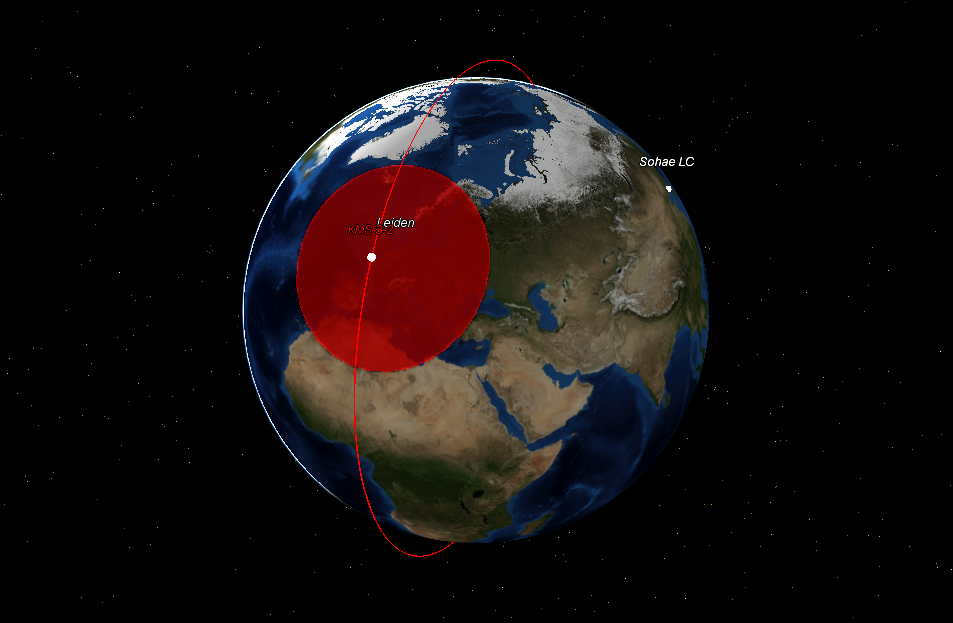
At the time, I did an analysis of the launch-window. It appeared to have been very carefully choosen to avoid coverage of the launch site (and specifically last-minute launch preparations) by Western reconnaissance satellites in the hour before the launch.
http://sattrackcam.blogspot.ch/search/label/Kwangmyongsong 3-2
Larger JPG image
Kwangmyŏngsŏng-3 (KMS 3-2) passing Deneb, evening of 10 Oct 2015
UPDATE (11 Oct 2015):
I imaged Kwangmyŏngsŏng-3 again the next evening (image above), 10 Oct 2015 near 18:32 UT, when it passed the bright star Deneb (brightest star in image). This time I used the Zeiss Sonnar MC 2.8/180mm lens, which shows fainter objects but has an even smaller FOV. The trail is faint but shows up well
Larger JPG image
Kwangmyŏngsŏng-3 (KMS 3-2), evening 9 Oct 2015
[original post before update:] Yesterday evening started clear. While my targets for that evening were the payloads of the NROL-55 launch from October 8 (more on that in a later post), I took the opportunity to image a pass of North-Korea's satellite Kwangmyŏngsŏng-3 (KMS 3-2) in the early part of the evening. The image above shows it, as a very faint trail.
Kwangmyŏngsŏng-3 (2012-072A) makes favourable passes in early autumn and in spring. In October it is making evening passes. Yesterday I had a very good illuminated pass near 20:50 local time (18:50 UT).
By coincidence my imaging of KMS 3-2 yesterday happened on the eve of the 70th anniversary of the Worker’s Party of Korea. There were rumours of a pending new N-Korean satellite launch, perhaps with a stronger rocket, on or near that date.
KMS 3-2 is a difficult object to photograph, as it is very faint: it is a cube of only about 1.0 x 0.75 meter in size. It is also tumbling. This makes it a challenge: it is in a Low Earth Orbit and moving relatively fast, but a lens which is fast enough to capture it during it's brief brightness peaks has a limited FOV. In practise, my f1.4/85mm lens can just show it during the brightest part of it's periodic brightness variability, but it is a gamble whether that happens in the FOV or not. So far I had managed to image it once before, a year ago.
Yesterday evening, I was lucky again: during a nice high late twilight pass with the the satellite culminating at an elevation of 60 degrees in the W-SW, it did reach peak brightness in the FOV of my lens, resulting in four images showing it. The best of these is shown above.
Larger JPG image
Kwangmyŏngsŏng-3 was launched three years ago, on 12 December 2012. It was the first successful launch by North-Korea, in the sense that the payload reached orbit. Whether the payload is operational (as PyongYang claimed), is another question. It's brightness behaviour shows it is tumbling, which is something an operational Earth Reconnaissance satellite should not do.
At the time, I did an analysis of the launch-window. It appeared to have been very carefully choosen to avoid coverage of the launch site (and specifically last-minute launch preparations) by Western reconnaissance satellites in the hour before the launch.
http://sattrackcam.blogspot.ch/search/label/Kwangmyongsong 3-2
Last edited:
