Here are the introduction of the satellites from the excellent web site by Gunter Krebs:
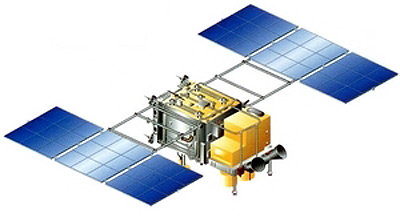
Payload 1: Kanopus-Vulkan 1
Kanopus-V (Kanopus-Vulkan) is a small Russian remote sensing satellite.
Provision of the Ministry of the Russian Federation for Civil Defense, Emergencies and Elimination of Consequences of Natural Disasters, Ministry of Natural Resources of the Russian Federation, the Federal Service for Hydrometeorology and Environmental Monitoring, Russian Academy of Sciences operational weather information for the following major tasks:
Monitoring of man-made and natural emergencies, including natural weather phenomena;
Mapping;
Detect pockets of forest fires and emissions of major pollutants in the environment;
Registration abnormal physical phenomena for earthquake prediction;
Monitoring of agriculture, water and coastal resources
Land use;
The satellite was built by NPO VNII Elektromekhaniki, who subcontracted the avionics suite to SSTL.
Kanopus-V feaures three prototype instruments:
PSS (Panchromatic Imaging System):
PSS is an instrument to provide panchromatic imagery for environmental monitoring, agriculture and forestry. It provides high resolution imagery of 2.5 m on a swath of 20 km. The spectral range is 0.5-0.8 µm.
MSS (Multispectral Imaging System):
MSS is an instrument to provide multispectral imagery of land and coastal surfaces and ice cover. It provides a spatial resolution of 12 m on a swath of 20 km. Four spectral bands are provided: 0.5-0.6 µm; 0.6-0.7 µm; 0.7-0.8 µm; 0.8-0.9 µm.
MSU-200 (Multispectral Scanner Unit):
MSU-200 is an instrument to provide imagery of land and sea surfaces and ice cover. The spatial resolution is 25 m on a swath of 250 km. The spectral coverage is 0.54-0.86 µm.
A virtual copy of this satellite was built for Belarus as BKA.
Payload 2: BKA / BelKA 2
BKA (formerly known as BelKa 2) is a Belarusian remote sensing satellite that replaces the BelKa 1 satellite lost in an launch failure.
The BKA satellite is a virtal copy of the russian Kanopus-V 1. The resolution up to 2.1 m and four spectral channels of the target-oriented equipment allow for national economic tasks to the benefit of MINECONOMRESURS, Ministry of Natural Resources, Federal Geodesy and Cartography Service, EMERCOM, etc. In addition to key tasks the spacecraft will enable scientific and applied researches in the Earth and atmosphere remote sensing.
The satellite was built by NPO VNII Elektromekhaniki, who subcontracted the avionics suite to SSTL.
The tasks to be fulfilled by BKA are:
Mapping (topographic and geodesic applications, government geodesic supervision);
Cadastral account of estate property;
Development of large building projects including gas and oil pipelines, railways, hydropower stations;
Geological investigations and conservation of mineral resources;
Environment monitoring including monitoring of forest fires and man-made emissions, glaciers and agricultural sector objects, etc.;
Monitoring of forest condition;
Monitoring of water bodies.
Payload 3: TET-1
TET-1 (Technologieerprobungsträger 1) is the core element of DLR's On-Orbit Verification Program(OOV). The main aim of this program is to test new space technologies in a space environment over a period of one year. Eleven experiments will be accommodated by Kayser-Threde on board the satellite which has a mass of 120 kg. The TET-Bus is based on the BIRD satellite structure. TET-1 is scheduled for launch mid 2010 on a SOYUZ/ FREGAT rocket as a secondary payload. The satellite will be released in a sun synchronous orbit at an altitude of approximately 500 km.
Kayser-Threde GmbH received in July 2008 the prime contract for the space and ground segment as well as launch services for the satellite mission TET-1 from the Space Agency of the German Aerospace Center (DLR). The project volume of the Phase C/D amounts to 21 million Euro. The TET-1 satellite platform was built by Astro- und Feinwerktechnik Adlershof GmbH (Astrofein) under contract of Kayser-Threde GmbH, who are the prime contractor for the mission.
The contract entrusts Kayser-Threde and its subcontractors with all aspects involved in the construction and manufacture of the satellite, the various tests for space flight qualification, the necessary infrastructure for the satellite mission and all preparations required for launch. The TET-1 mission will be carried out under contract to DLR with funds from the German Ministry for Economics and Technology (Bundesministerium für Wirtschaft und Technologie).
More photos here:
http://www.kayser-threde.de/tet/images/TET-1_Baikonur_2012-07/Pics-Baikonur/
Payload 4: exactView 1
exactView 1 (EV 1), formerly known as ADS-1b, will form part of the exactEarth (COM DEV) AIS constellation to monitor ship movements through busy shipping channels and harbours and to provide information on global shipping movements. It is a follow-up mission to the CanX 6/NTS satellite.
The Automatic Identification System (AIS) is a self-organizing TMDA radiocommunication system used for the identification and location of maritime vessels. AIS transponders are required by the International Maritime Organization on all vessels over 300 tonnes and all passenger vessels. Communication is line-of-sight, allowing countries to monitor ships within about 50 km of their shores. A space-based platform allows monitoring of much larger areas, especially in areas that are difficult to monitor through more traditional base station means.
exactView 1 features a AIS payload with two polarizations and four channels and a C-band data downlink.
More photos here:
http://www.sstl.co.uk/launches/exactview-1/gallery
Payload 5: Zond-PP / MKA-PN1
Zond-PP or MKA-PN 1 is a microsatellite designed to study the characteristics of the earth's surface by using a L-band UHF panoramic radiometer and is aimed at mapping of soil moisture and water salinity waters, and study the land-ocean-atmosphere energy system. The results will be used for forecasting changes in the environment and climate.
Additionally a multi-spectral camera (Pribor EK) was installed onboard as a secondary payload.
The Zond-PP is based on Lavochkin's Karat microsatellite bus.
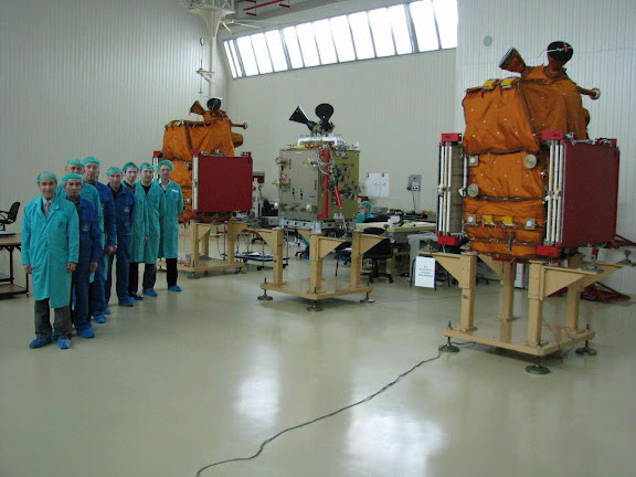
And here are photos and videos of the launch campaign: