Problem surface tiles problem!

crazydogg

New member
Joined
Aug 16, 2010
Messages
20
Reaction score
0
Points
0
I'm doing an air base, but I have a problem that does not know how to solve! the surface tiles are crazy:facepalm:, it seems they are in the right place, but they are not aligned.
2h7e3w0.jpg

I think to solve simply rotate the tiles, but I do not understand why this happened, I had made them from a single large image,
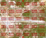
it might help too:
Code:
BEGIN_SURFTILELIST
6 -2952 -352 1
6 -2952 -353 1
6 -2952 -351 1
6 -2952 -350 1
6 -2952 -349 1
6 -2951 -353 1
6 -2951 -352 1
6 -2951 -351 1
6 -2951 -350 1
6 -2951 -349 1
6 -2950 -349 1
6 -2950 -350 1
6 -2950 -351 1
6 -2950 -352 1
6 -2950 -353 1
6 -2949 -349 1
6 -2949 -350 1
6 -2949 -351 1
6 -2949 -352 1
6 -2949 -353 1
6 -2948 -349 1
6 -2948 -350 1
6 -2948 -351 1
6 -2948 -352 1
6 -2948 -353 1
6 -2947 -349 1
6 -2947 -350 1
6 -2947 -351 1
6 -2947 -352 1
6 -2947 -353 1
END_SURFTILELIST
 
How did you make the tiles?

N.
 
Can you post a screenshot showing a view of full image as seen in image viewer (or editor)?
 
n5pus.jpg

this is the entire image, I cut it into pieces of 256px by 256px, and renamed them according to the indications of surface tiles calc.
 
Well, you have them numbered from wrong side. The numbering would be just right for positive coordinate tiles, but these are negative. I haven't used surface tiles calc ever, to check if it's the cause for your issue, but I used the Windows Calculator instead if I needed to make surface tiles for bases. Maybe you have put there positive coordinates instead of negative for calculation (?).

You need to rename the tiles by switching the order of them for both horizontal and vertical position (i.e. to flip the top-left tiles to bottom-right).

If the image's top is North, bottom - South, left - West, right - East, and the calculated coordinates are correct, then you need to rename your DDS tiles to use coordinates like on the attached image.
 

Attachments

  • crazydogg-tiles.jpg
    crazydogg-tiles.jpg
    265.8 KB · Views: 20
Out of curiosity crazydog, what airfield is that?

N.
 
Out of curiosity crazydog, what airfield is that?

N.

After converting coordinates, according to Google Earth it's Fernando de Noronha (32.42 W, 3.85 S).
 
is the island of "Fernando de Noronha," for a few decades she has worked with prison and was under military command in the 2nd war, was a strategic place for transporting cargo and personnel between the south america and africa, I'm doing a rocket launcher complex here.
More details about Fernando de Noronha:[ame="http://en.wikipedia.org/wiki/Fernando_de_Noronha"]http://en.wikipedia.org/wiki/Fernando_de_Noronha[/ame]
thanks for the help Orb:cheers:, I'll try that!:thumbup:
 
Back
Top