- Joined
- Feb 13, 2008
- Messages
- 5,398
- Reaction score
- 8
- Points
- 0
- Location
- Khimki
- Website
- tigerofsiberia.livejournal.com
At present, effective reaching of the goals of meteorology is impossible without use of data supplied by Earth remote sensing satellites. One of such valuable assets is a network of satellites positioned at the Geostationary orbit. The World's Meteorological Organization superwises international network of GEO weather sensing satellites, which is formed by American GOES constellation satellites, European Meteosat, Russian GOMS №1/Elektro №1 (non-functional since 1998), and Japanese GMS. Also, there are Indian Insat and Metsat, and Chinese FY-2 weather sensing satellites at GEO.

The new Russian weather satellite Electro-L, built in 2010, has iternational designation GOMS №2 (Geostationary Operational Meteorological Satellite). It is intended to supply Russian Hydrometeorology and Environmental Monitoring agency with following kinds of information:
Elektro-L should be able to image multispectrally the entire visible hemisphere of Earth with resolution of 1 km per pixel (visible light band) and 4 km (IR band), every 30 minutes. In emergency cases, like during natural disaster's development observations, frequency of imaging may be increased to once in every 10-15 minutes, at command from the ground.
In addition to that, Elektro-L will obtain space environment data, relay and exchange meteorological data between autonomous weather platforms and other satellites, and also receive distress signals from SARSAT beacons.


Launch location:
Baikonur Launch pad no. 45/1 45°56'35.87"N, 63°39'10.83"E
Launch dates and times:
{colsp=6}Launch times
Time Zone |
{colsp=6}
{colsp=6}
Live Coverage Of The Launch:
PAYLOAD
Elektro-L (GOMS №2) meteorology satellite:
Spacecraft Overview
Elektro-L is a second generation geostationary weather monitoring spacecraft, built and operated by Russia.
The spacecraft is designed to have modular composition. It consists of Service Systems Module and Payload Module. The former is represented by Navigator universal bus, which is developed by Lavochkin Space for use as a core in various spacecraft, such as Spektr series orbiting observatories.
Mass of the spacecraft in operational mode is about 1500 kg. Its effective lifetime should be no shorter than 10 years.
Electro-L is designed as an elevated operational compatibility spacecraft. When assembling and electric tests of the spacecraft are done at Lavochkin Centre, the satellite is delivered to a cosmodrome virtually ready to fly. This technology allows for significant cost savings on launch preparatory works.
{colsp=2}Summary
Parameter | Value
Characteristics|

Band #|Wavelengths (mkm)|Singal/Noise ratio or bolometric resolution|Usage
1,2|0.5 – 0.65,0.65 – 0.8|>10|Cloud observations, tracer cloud tracking for wind direction determination, aerosol observations
3|0.8 - 0.9|>7|Watching clouds of small sizes
4|3.5 - 4.01|<0.35°K|Detecting low clouds, night ocean and land temperature
5|5.7 - 7.0 |<0.75°K|Water vapour watching, wind determination, semi-transparent clouds
6,7|7.5 – 8.5, 8.2 - 9.2|<0.28°K|Observations of semi-transparent layered clouds
8|9.2 - 10.2|<1.5°K|Monitoring of Ozone concentration, wind in low stratosphere
9,10|10.2 - 11.2,11.2 - 12.5|<0.3°K|Ocean and land temperature determination, amount of precipitation over oceans
|

Launch Vehicle:
{colsp=2}Characteristics
 |
|
{colsp=2}

The vehicle's reliability statistics according to http://www.spacelaunchreport.com/reliability2010.txt:
Zenit is first flown in such configuration, so there we can assume 50% reliability...
For Zenit-3SLБ,
Launch Azimuth drawing
(don't try to click controls, he-heee...)
Elektro-L Ascent Profile
Orbit #|Orbit Nature|Perigee h, km|Apogee H, km|Inclination
1|Parking|178|640|51.3°
2|Intermediate|306|4 440|50.4°
3|GEO-transfer|361|35 914|48.6°
4|Target GEO|35 413.6|35 785.8|0.5°
4|Fregat Disposal|34 195.8|35 718.9|0.5°
Elektro-L Ascent Timeline

Event|Time MSK|Time UTC|Comment
Lift-off|15:29:01|12:29:01|
2nd/upper Stage Separation|15:37:38|12:37:38|
1st Burn Ignition|16:44:26|13:44:26|
1st Burn Shutdown|16:52:40|13:52:40|1st Burn's Duration 00:08:14
APT Jettison|16:53:17|13:53:17|
2nd Burn Ignition|18:58:20|15:58:20|
2nd Burn Shutdown|19:08:59|16:08:59|2nd Burn's Duration 00:10:29
3rd Burn Ignition|00:19:06 (Jan 21st)|21:19:06|
3rd Burn Shutdown|00:27:43|21:27:43|3rd Burn's Duration 00:08:37
Spacecraft Separation |00:28:13 (Jan 21st)|21:28:13|
Fregat disposal burn Ignition|03:28:19|00:28:19 (Jan 21st)
Fregat disposal burn Ignition|03:29:39|00:29:39|Disposal Durn's Duration 00:01:20
Weather forecast for Baikonur, Kazakhstan on January 20, 2011 (5 p.m.)
Time|Temps|Wind|Chill|Heat Index|UV Index|Dew Point|Relative Humidity|Precip|Snow|Clouds|Visibility|Wind|Weather
5 PM|0°C|-2°C|0°C|0|Low|-4°C|70%|20%|19%|53%|16KM|SW 1.34 m/s|
 P Cloudy
Sunrise/Sunset and associated twilight times for Baikonur on Thursday, January 20, 2011
Times are local.
Event|Time
Astronomical twilight begins|07 : 35
Nautical twilight begins|08 : 11
Civil twilight begins|08 : 47
Sunrise|09 : 18
Transit (sun is at its highest)|13 : 57
Sunset|18 : 36
Civil twilight ends|19 : 07
Nautical twilight ends|19 : 44
Astronomical twilight ends|20 : 19
References
http://www.federalspace.ru
http://tvroscosmos.ru
http://www.tsenki.com
http://www.laspace.ru
http://planeta.infospace.ru/electro/
http://rocketpolk44.narod.ru
http://www.yuzhmash.com
http://www.yuzhnoye.com
http://forum.nasaspaceflight.com
http://www.novosti-kosmonavtiki.ru
http://www.spacelaunchreport.com
http://www.geomidpoint.com/destination/
http://www.gpsvisualizer.com/calculators
http://www.intellicast.com/Local/Forecast.aspx
http://www.good-stuff.co.uk/suntimes/sunmap.php
The new Russian weather satellite Electro-L, built in 2010, has iternational designation GOMS №2 (Geostationary Operational Meteorological Satellite). It is intended to supply Russian Hydrometeorology and Environmental Monitoring agency with following kinds of information:
- Weather analysis and forecasting on global and regional scale.
- Analysis and forecasting of conditions at seas and oceans.
- Assessing and forecasting weather conditions affecting air traffic.
- Probing and forecasting ionospheric conditions in the near space and Earth's magnetic field.
- Monitoring of climate and global changes in environment.
- Assessing conditions and developments at disaster sites.
- Monitoring activities harmful to natural environment.
Elektro-L should be able to image multispectrally the entire visible hemisphere of Earth with resolution of 1 km per pixel (visible light band) and 4 km (IR band), every 30 minutes. In emergency cases, like during natural disaster's development observations, frequency of imaging may be increased to once in every 10-15 minutes, at command from the ground.
In addition to that, Elektro-L will obtain space environment data, relay and exchange meteorological data between autonomous weather platforms and other satellites, and also receive distress signals from SARSAT beacons.
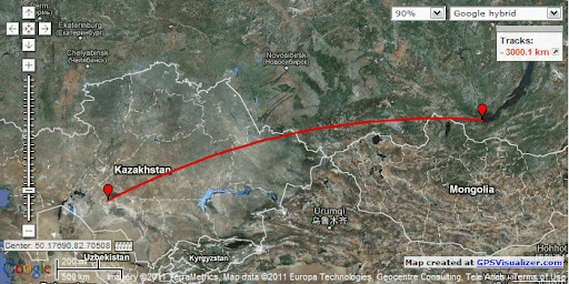
Launch location:
Baikonur Launch pad no. 45/1 45°56'35.87"N, 63°39'10.83"E
Launch dates and times:
Time Zone |
Australia - Sydney/AEST
|
Baikonur / UTC+6
|
Moscow / MSK/
|
Universal / UTC
|
Washington / EST
Launch time (Primary):
|
10:29:01 p.m.
|
17:29:01
|
15:29:01
|
12:29:01
|
7:29:01 a.m.
on:
|
Jan. 20, 2011
|
Jan. 20, 2011
|
Jan. 20, 2011
|
Jan. 20, 2011
|
Jan. 20, 2011
{colsp=6}
[highlight][eventTimer]2011-01-20 12:29:01?before|after;%dd% Days %hh% Hours %mm% Minutes %ss% Seconds %c%[/eventTimer] Elektro-L Launch[/highlight]
{colsp=6}
[highlight][eventTimer]2011-01-20 22:28:13?before|after;%dd% Days %hh% Hours %mm% Minutes %ss% Seconds %c%[/eventTimer] Elektro-L Separation From the Launch Vehicle[/highlight]
Live Coverage Of The Launch:
- TSENKI Video Streams: http://www.tsenki.com/broadcast/broadcast/ - coverage since 13:30 MSK (10:30 a.m. UTC) till 16:30 MSK (13:30 UTC)
- Vesti (short stand-up right before launch): http://www.vesti.ru/videos?vid=onair
PAYLOAD
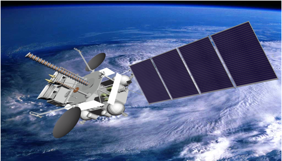
Elektro-L (GOMS №2) meteorology satellite:
Spacecraft Overview
Elektro-L is a second generation geostationary weather monitoring spacecraft, built and operated by Russia.
The spacecraft is designed to have modular composition. It consists of Service Systems Module and Payload Module. The former is represented by Navigator universal bus, which is developed by Lavochkin Space for use as a core in various spacecraft, such as Spektr series orbiting observatories.
Mass of the spacecraft in operational mode is about 1500 kg. Its effective lifetime should be no shorter than 10 years.
Electro-L is designed as an elevated operational compatibility spacecraft. When assembling and electric tests of the spacecraft are done at Lavochkin Centre, the satellite is delivered to a cosmodrome virtually ready to fly. This technology allows for significant cost savings on launch preparatory works.
Parameter | Value
Working Orbit:
|
GEO
Orbital Location:
|
76° East
Coverage:
|
Indo-Pacific hemisphere of Earth
ApA at separation:
|
35 785.8 km
PeA at separation:
|
35 413.6 km
Inc at separation:
|
0.5°Elektro-L
Parts diagram:
|
Customer:
|- Russian RosHydroMet Weather and Environmental Monitoring Agency
Prime contractor:
|- Lavochkin Association (NPO)

Platform:
|- Navigator
Mass at Separation:
|- 1 740 kg
Dry Mass:
|- ?
Stabilization:
|- 3 axis stabilized
Dimensions:
|- ?
Batteries:
|- ?
Primary Meteorology Payload:
|MSU-GS (Multispectral Imager)- Working conditions: Sun elevation 10-90°, albedo 0.07-0.9, object contrast 0.2-0.7
- Imaging zone angular width: 20°x20°
- Observed spectrum bands: 10, ranging fro, 0.5 to 12.5 mkm (see band breakdown below)
1,2|0.5 – 0.65,0.65 – 0.8|>10|Cloud observations, tracer cloud tracking for wind direction determination, aerosol observations
3|0.8 - 0.9|>7|Watching clouds of small sizes
4|3.5 - 4.01|<0.35°K|Detecting low clouds, night ocean and land temperature
5|5.7 - 7.0 |<0.75°K|Water vapour watching, wind determination, semi-transparent clouds
6,7|7.5 – 8.5, 8.2 - 9.2|<0.28°K|Observations of semi-transparent layered clouds
8|9.2 - 10.2|<1.5°K|Monitoring of Ozone concentration, wind in low stratosphere
9,10|10.2 - 11.2,11.2 - 12.5|<0.3°K|Ocean and land temperature determination, amount of precipitation over oceans
- Per pixel resultion in nadir: channels 1-3 (visible light) no more than 1 km/pix; channels 4-10 (IR light) no more 4 km/pix.
- Pixels per scan line for 0.5-0.8 mkm bands: 12 576
- Pixels per scan line for 3.5-12.5 mkm bands: 3 144
- Scans in one frame: 34
- Range of measured temperatures, K: 220 - 340
- Time to obtain one frame, at 0.5-0.8 mkm: <= 15 mins
- Time to obtain one frame, at 3.5-12.8 mkm: <= 2 mins
- Full information output bitrate, kbit/s: 3150 - 4000
- Working mode: session-like, with one session in 30 mins in standard and once in 15 mins in emergency mode
- Powering up time: 5 minutes
- Imaging method: mirror at discrete steps
- Power consumption, W: <= 200
- Instrument dimensions, mm: 875 х 520 х 450
- Instrument mass, kg: <= 88
Space Weather Payload:
|GGAK-E (Space Environment Prober) provides the following measurements:- Integral Solar Constant in energy range 0.2 - 100.0 mkm
- Differential Energy Spectrae of electrons and protons in energy range 0.05 - 20.0 kEv
- Electron flux density in ranges: 0.03, 0.1-0.7, 2.0-4.0, 6.0; > 6.0 MEv
- Proton flux density in ranges: 0.5, 3.0-10.0, 30.0, 50.0, 100.0, 300.0; >300.0, >600.0 MEv
- Soft X-Ray Solar radiation intensity in range 3.0-10.0 kEv
- UV Solar radiation intencity in resonance line HL-alpha (121.6 nm)
- Triple-orthogonal axes magnetometry (up to 300.0 nT)
Information Payload:
|BSSD is an onboard data processing system with the following functions:- Accumulation of data from MSU-GS
- Accumulation of data from GGAK-E
- Accumulation of operational information from spacecraft systems
- Storage of the data
- Replaying and transformation of the data for transmitting over the radio link
Radio Communication Assembly:
|Provides for the following functions:- Downlinking imagery information over 7.5 GHz band at 15.26 Mbit/s (single-band phase modulation)
- Downlinking space environment readings over 1.7 GHz band at 2500 bit/s
- Uplinking meteo information from autonomous surface platforms over 401-403 MHz band, from LEO satellites at 470 MHz, and their downlinking over 1.7 GHz band in phase modulated form.
- Relaying processed Hydrometeorology and Space Weather data (in HRIT, LRIT messages over 8.2 GHz uplink / 1.7 GHz downlink; in plain form at 15.36 Mbit/s over 8.2 GHz uplink / 7.5 GHz downlink)
- SARSAT distress calls relaying (over 406 MHz uplink, 1.54 GHz downlink)
- Uplinking and downlinking at 8.2 and 7.5 GHz are carried out via targetable high-gain antennae.
Life time:
|- 10 years
|
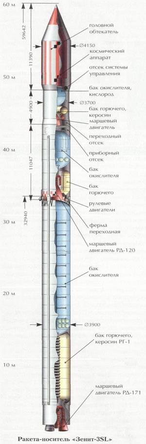
Launch Vehicle:
Zenit-3SLБФ (or Zenit-3F) / Fregat-SB
Prime contractor:
|- Yuzhmash (A.M. Makarov Yuzhny Machine-Building Plant) - Ukraine

GRAU Index:
|- 11K77
Height:
| 58.7 m with upper stage and payload fairing
(figure is for Z-3SLБ)
Diameter:
| max 4.1 mLiftoff mass:
| 473 metric tonnes
(figure is for Z-3SLБ)
Payload mass:
| ~13.7 tonnes at LEO1st stage:
|- 1 X RD-171 engine
- Empty 33.9 tonnes
- Propellants 318.8 tonnes (RG-1 Kerosene and LOX)
- Thrust in vacuum 7 908 kN
- Thrust at sea level 7 259 kN
2nd stage:
|- 1 X RD-120 engine + 1 X RD-8 vernier engine
- Empty 9.3 tonnes
- Propellants 80.6 tonnes (RG-1 Kerosene and LOX)
- Thrust in vacuum 834 + 78 kN
Upper Stage:
|
- GRAU Index: -
- Common Name: Fregat-SB (meaning Frigate)
- Designer & Manufacturer: Lavochkin Association (NPO)
- Dimensions: Length 2.4 m, Diameter (max) 3.875 m
- Empty Mass 1.05 tonnes
- APT Empty Mass 360 kg
- Propellants 7100 kg max
- Main Engine: 1 X S5.92
- Thrust in vacuum 2.0 tonnes of force (full power)
- Thrust in vacuum 1.4 tonnes of force (small power)
- ISP 333.2 s
Payload Fairing:
|- Diameter 4.1 m
- Length 10.4 m
The vehicle's reliability statistics according to http://www.spacelaunchreport.com/reliability2010.txt:
Zenit is first flown in such configuration, so there we can assume 50% reliability...
For Zenit-3SLБ,
Code:
================================================================
Vehicle     Successes/Tries Realzd Pred  Consc. Last     Dates
                             Rate  Rate* Succes Fail
================================================================
Zenit 3SLB/DMSLB 3 4 .75 .67 3(B) 4/28/08 2008-(don't try to click controls, he-heee...)
Elektro-L Ascent Profile
1|Parking|178|640|51.3°
2|Intermediate|306|4 440|50.4°
3|GEO-transfer|361|35 914|48.6°
4|Target GEO|35 413.6|35 785.8|0.5°
4|Fregat Disposal|34 195.8|35 718.9|0.5°
Elektro-L Ascent Timeline
Lift-off|15:29:01|12:29:01|
2nd/upper Stage Separation|15:37:38|12:37:38|
1st Burn Ignition|16:44:26|13:44:26|
1st Burn Shutdown|16:52:40|13:52:40|1st Burn's Duration 00:08:14
APT Jettison|16:53:17|13:53:17|
2nd Burn Ignition|18:58:20|15:58:20|
2nd Burn Shutdown|19:08:59|16:08:59|2nd Burn's Duration 00:10:29
3rd Burn Ignition|00:19:06 (Jan 21st)|21:19:06|
3rd Burn Shutdown|00:27:43|21:27:43|3rd Burn's Duration 00:08:37
Spacecraft Separation |00:28:13 (Jan 21st)|21:28:13|
Fregat disposal burn Ignition|03:28:19|00:28:19 (Jan 21st)
Fregat disposal burn Ignition|03:29:39|00:29:39|Disposal Durn's Duration 00:01:20
Weather forecast for Baikonur, Kazakhstan on January 20, 2011 (5 p.m.)
5 PM|0°C|-2°C|0°C|0|Low|-4°C|70%|20%|19%|53%|16KM|SW 1.34 m/s|
Times are local.
Astronomical twilight begins|07 : 35
Nautical twilight begins|08 : 11
Civil twilight begins|08 : 47
Sunrise|09 : 18
Transit (sun is at its highest)|13 : 57
Sunset|18 : 36
Civil twilight ends|19 : 07
Nautical twilight ends|19 : 44
Astronomical twilight ends|20 : 19
http://www.federalspace.ru
http://tvroscosmos.ru
http://www.tsenki.com
http://www.laspace.ru
http://planeta.infospace.ru/electro/
http://rocketpolk44.narod.ru
http://www.yuzhmash.com
http://www.yuzhnoye.com
http://forum.nasaspaceflight.com
http://www.novosti-kosmonavtiki.ru
http://www.spacelaunchreport.com
http://www.geomidpoint.com/destination/
http://www.gpsvisualizer.com/calculators
http://www.intellicast.com/Local/Forecast.aspx
http://www.good-stuff.co.uk/suntimes/sunmap.php
Last edited:


 :woohoo: